You are here: Home > Network List > CI - Caltech Regional Seismic Network Stations List
> Station MPM Manuel Prospect Mine, California, USA > Earthquake Result Viewer
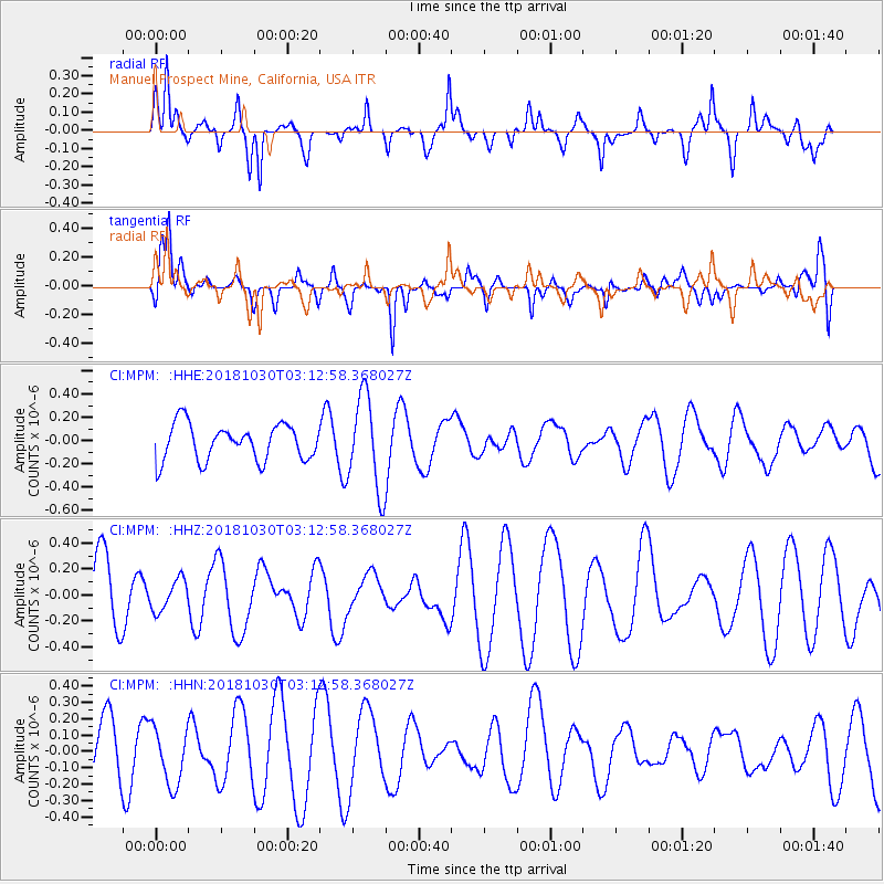
MPM Manuel Prospect Mine, California, USA - Earthquake Result Viewer
*The percent match for this event was below the threshold and hence no stack was calculated.
| Earthquake location: |
Ionian Sea |
| Earthquake latitude/longitude: |
37.5/20.4 |
| Earthquake time(UTC): |
2018/10/30 (303) 02:59:58 GMT |
| Earthquake Depth: |
10 km |
| Earthquake Magnitude: |
5.6 mb |
| Earthquake Catalog/Contributor: |
NEIC PDE/us |
|
| Network: |
CI Caltech Regional Seismic Network |
| Station: |
MPM Manuel Prospect Mine, California, USA |
| Lat/Lon: |
36.06 N/117.49 W |
| Elevation: |
185 m |
|
| Distance: |
97.0 deg |
| Az: |
326.834 deg |
| Baz: |
32.462 deg |
| Ray Param: |
$rayparam |
*The percent match for this event was below the threshold and hence was not used in the summary stack. |
|
| Radial Match: |
71.74893 % |
| Radial Bump: |
400 |
| Transverse Match: |
63.123047 % |
| Transverse Bump: |
400 |
| SOD ConfigId: |
13570011 |
| Insert Time: |
2019-05-01 16:41:44.234 +0000 |
| GWidth: |
2.5 |
| Max Bumps: |
400 |
| Tol: |
0.001 |
|
Signal To Noise
| Channel | StoN | STA | LTA |
| CI:MPM: :HHZ:20181030T03:12:58.368027Z | 0.6260933 | 1.1961998E-7 | 1.9105777E-7 |
| CI:MPM: :HHN:20181030T03:12:58.368027Z | 0.7236009 | 1.765548E-7 | 2.4399472E-7 |
| CI:MPM: :HHE:20181030T03:12:58.368027Z | 2.6097653 | 4.0320592E-7 | 1.5449892E-7 |
| Arrivals |
| Ps | |
| PpPs | |
| PsPs/PpSs | |


