You are here: Home > Network List > TA - USArray Transportable Network (new EarthScope stations) Stations List
> Station Y20A Horse Springs, Datil, NM, USA > Earthquake Result Viewer
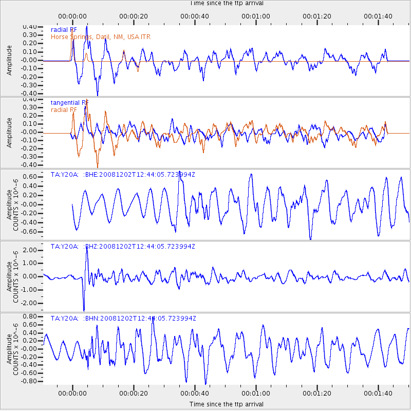
Y20A Horse Springs, Datil, NM, USA - Earthquake Result Viewer
*The percent match for this event was below the threshold and hence no stack was calculated.
| Earthquake location: |
Mariana Islands |
| Earthquake latitude/longitude: |
19.1/145.8 |
| Earthquake time(UTC): |
2008/12/02 (337) 12:31:43 GMT |
| Earthquake Depth: |
137 km |
| Earthquake Magnitude: |
5.9 MB, 5.9 MW, 5.9 MW |
| Earthquake Catalog/Contributor: |
WHDF/NEIC |
|
| Network: |
TA USArray Transportable Network (new EarthScope stations) |
| Station: |
Y20A Horse Springs, Datil, NM, USA |
| Lat/Lon: |
33.91 N/108.38 W |
| Elevation: |
2177 m |
|
| Distance: |
92.0 deg |
| Az: |
53.17 deg |
| Baz: |
294.486 deg |
| Ray Param: |
$rayparam |
*The percent match for this event was below the threshold and hence was not used in the summary stack. |
|
| Radial Match: |
60.315266 % |
| Radial Bump: |
346 |
| Transverse Match: |
54.11786 % |
| Transverse Bump: |
369 |
| SOD ConfigId: |
2658 |
| Insert Time: |
2010-03-06 17:22:09.901 +0000 |
| GWidth: |
2.5 |
| Max Bumps: |
400 |
| Tol: |
0.001 |
|
Signal To Noise
| Channel | StoN | STA | LTA |
| TA:Y20A: :BHZ:20081202T12:44:05.723994Z | 6.442317 | 9.146322E-7 | 1.4197256E-7 |
| TA:Y20A: :BHN:20081202T12:44:05.723994Z | 0.7044253 | 1.678613E-7 | 2.3829541E-7 |
| TA:Y20A: :BHE:20081202T12:44:05.723994Z | 1.4991531 | 3.3587077E-7 | 2.2404032E-7 |
| Arrivals |
| Ps | |
| PpPs | |
| PsPs/PpSs | |


