You are here: Home > Network List > TA - USArray Transportable Network (new EarthScope stations) Stations List
> Station Y20A Horse Springs, Datil, NM, USA > Earthquake Result Viewer
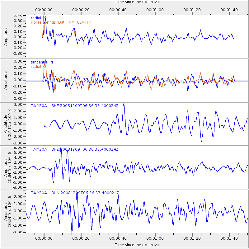
Y20A Horse Springs, Datil, NM, USA - Earthquake Result Viewer
*The percent match for this event was below the threshold and hence no stack was calculated.
| Earthquake location: |
Kermadec Islands Region |
| Earthquake latitude/longitude: |
-31.2/-176.9 |
| Earthquake time(UTC): |
2008/12/09 (344) 06:23:59 GMT |
| Earthquake Depth: |
18 km |
| Earthquake Magnitude: |
6.2 MB, 6.7 MS, 6.8 MW, 6.7 MW |
| Earthquake Catalog/Contributor: |
WHDF/NEIC |
|
| Network: |
TA USArray Transportable Network (new EarthScope stations) |
| Station: |
Y20A Horse Springs, Datil, NM, USA |
| Lat/Lon: |
33.91 N/108.38 W |
| Elevation: |
2177 m |
|
| Distance: |
91.5 deg |
| Az: |
50.742 deg |
| Baz: |
232.895 deg |
| Ray Param: |
$rayparam |
*The percent match for this event was below the threshold and hence was not used in the summary stack. |
|
| Radial Match: |
75.12137 % |
| Radial Bump: |
400 |
| Transverse Match: |
46.917385 % |
| Transverse Bump: |
356 |
| SOD ConfigId: |
2658 |
| Insert Time: |
2010-03-06 17:22:17.931 +0000 |
| GWidth: |
2.5 |
| Max Bumps: |
400 |
| Tol: |
0.001 |
|
Signal To Noise
| Channel | StoN | STA | LTA |
| TA:Y20A: :BHZ:20081209T06:36:33.400024Z | 2.9099786 | 1.0860817E-6 | 3.732267E-7 |
| TA:Y20A: :BHN:20081209T06:36:33.400024Z | 2.0636096 | 9.775264E-7 | 4.7369733E-7 |
| TA:Y20A: :BHE:20081209T06:36:33.400024Z | 0.856973 | 3.7549205E-7 | 4.381609E-7 |
| Arrivals |
| Ps | |
| PpPs | |
| PsPs/PpSs | |


