You are here: Home > Network List > TA - USArray Transportable Network (new EarthScope stations) Stations List
> Station F21K Alatna River, AK, USA > Earthquake Result Viewer
F21K Alatna River, AK, USA - Earthquake Result Viewer
*The percent match for this event was below the threshold and hence no stack was calculated.
| Earthquake location: |
Ionian Sea |
| Earthquake latitude/longitude: |
37.5/20.5 |
| Earthquake time(UTC): |
2018/10/30 (303) 15:12:00 GMT |
| Earthquake Depth: |
11 km |
| Earthquake Magnitude: |
5.7 Mww |
| Earthquake Catalog/Contributor: |
NEIC PDE/us |
|
| Network: |
TA USArray Transportable Network (new EarthScope stations) |
| Station: |
F21K Alatna River, AK, USA |
| Lat/Lon: |
67.22 N/153.48 W |
| Elevation: |
597 m |
|
| Distance: |
75.5 deg |
| Az: |
357.587 deg |
| Baz: |
4.933 deg |
| Ray Param: |
$rayparam |
*The percent match for this event was below the threshold and hence was not used in the summary stack. |
|
| Radial Match: |
74.25589 % |
| Radial Bump: |
400 |
| Transverse Match: |
68.07905 % |
| Transverse Bump: |
400 |
| SOD ConfigId: |
13570011 |
| Insert Time: |
2019-05-01 16:54:54.591 +0000 |
| GWidth: |
2.5 |
| Max Bumps: |
400 |
| Tol: |
0.001 |
|
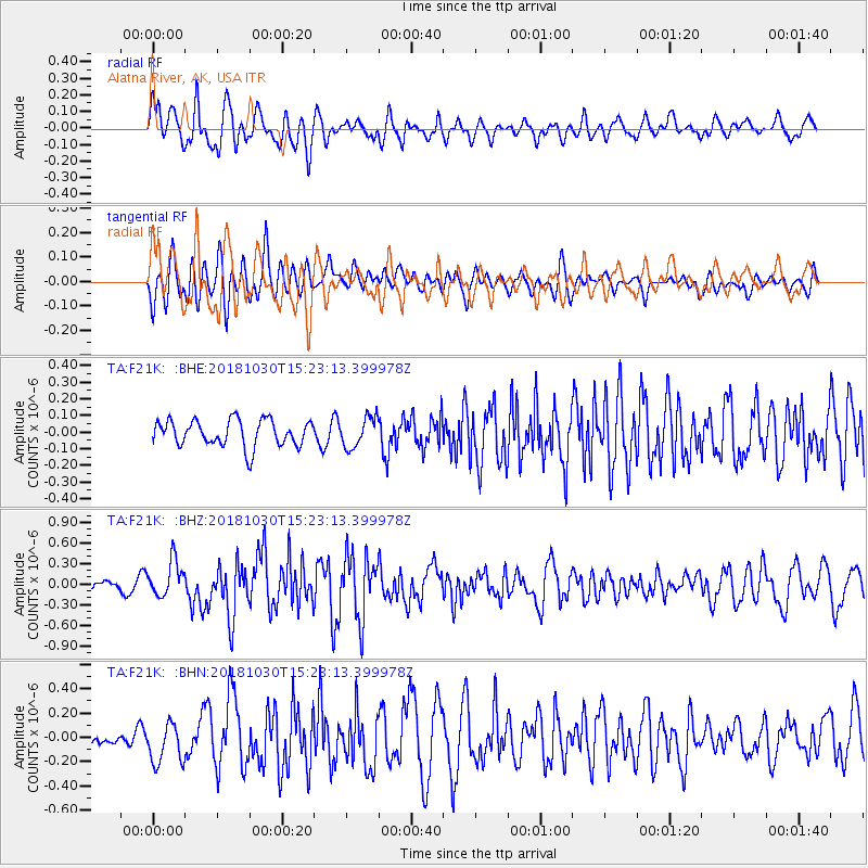
Signal To Noise
| Channel | StoN | STA | LTA |
| TA:F21K: :BHZ:20181030T15:23:13.399978Z | 4.717357 | 2.599204E-7 | 5.509873E-8 |
| TA:F21K: :BHN:20181030T15:23:13.399978Z | 1.8950908 | 1.6835804E-7 | 8.883904E-8 |
| TA:F21K: :BHE:20181030T15:23:13.399978Z | 1.1548324 | 9.08872E-8 | 7.870164E-8 |
| Arrivals |
| Ps | |
| PpPs | |
| PsPs/PpSs | |


