You are here: Home > Network List > TA - USArray Transportable Network (new EarthScope stations) Stations List
> Station F26K Sheenjek River, AK, USA > Earthquake Result Viewer
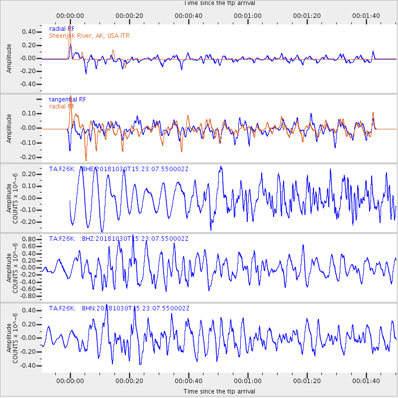
F26K Sheenjek River, AK, USA - Earthquake Result Viewer
*The percent match for this event was below the threshold and hence no stack was calculated.
| Earthquake location: |
Ionian Sea |
| Earthquake latitude/longitude: |
37.5/20.5 |
| Earthquake time(UTC): |
2018/10/30 (303) 15:12:00 GMT |
| Earthquake Depth: |
11 km |
| Earthquake Magnitude: |
5.7 Mww |
| Earthquake Catalog/Contributor: |
NEIC PDE/us |
|
| Network: |
TA USArray Transportable Network (new EarthScope stations) |
| Station: |
F26K Sheenjek River, AK, USA |
| Lat/Lon: |
67.69 N/144.15 W |
| Elevation: |
683 m |
|
| Distance: |
74.5 deg |
| Az: |
353.981 deg |
| Baz: |
12.617 deg |
| Ray Param: |
$rayparam |
*The percent match for this event was below the threshold and hence was not used in the summary stack. |
|
| Radial Match: |
55.514713 % |
| Radial Bump: |
400 |
| Transverse Match: |
62.97617 % |
| Transverse Bump: |
400 |
| SOD ConfigId: |
13570011 |
| Insert Time: |
2019-05-01 16:54:55.809 +0000 |
| GWidth: |
2.5 |
| Max Bumps: |
400 |
| Tol: |
0.001 |
|
Signal To Noise
| Channel | StoN | STA | LTA |
| TA:F26K: :BHZ:20181030T15:23:07.550002Z | 2.728372 | 2.601348E-7 | 9.534433E-8 |
| TA:F26K: :BHN:20181030T15:23:07.550002Z | 0.729912 | 9.1630696E-8 | 1.2553663E-7 |
| TA:F26K: :BHE:20181030T15:23:07.550002Z | 0.66101974 | 1.00964996E-7 | 1.5274126E-7 |
| Arrivals |
| Ps | |
| PpPs | |
| PsPs/PpSs | |


