You are here: Home > Network List > TM - Thai Seismic Monitoring Network Stations List
> Station MHIT MHIT Phase1 > Earthquake Result Viewer
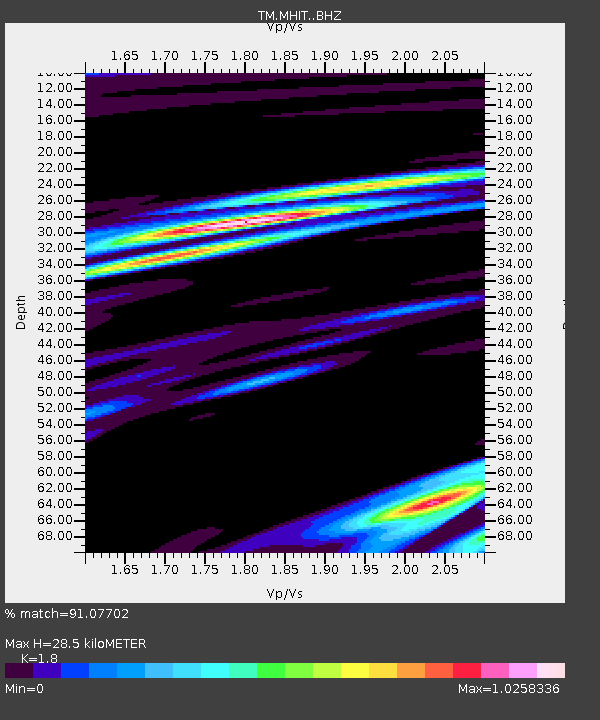
MHIT MHIT Phase1 - Earthquake Result Viewer
| Earthquake location: |
Ionian Sea |
| Earthquake latitude/longitude: |
37.5/20.5 |
| Earthquake time(UTC): |
2018/10/30 (303) 15:12:00 GMT |
| Earthquake Depth: |
11 km |
| Earthquake Magnitude: |
5.7 Mww |
| Earthquake Catalog/Contributor: |
NEIC PDE/us |
|
| Network: |
TM Thai Seismic Monitoring Network |
| Station: |
MHIT MHIT Phase1 |
| Lat/Lon: |
19.31 N/97.96 E |
| Elevation: |
270 m |
|
| Distance: |
68.7 deg |
| Az: |
81.543 deg |
| Baz: |
303.608 deg |
| Ray Param: |
0.05609903 |
| Estimated Moho Depth: |
28.5 km |
| Estimated Crust Vp/Vs: |
1.80 |
| Assumed Crust Vp: |
6.316 km/s |
| Estimated Crust Vs: |
3.509 km/s |
| Estimated Crust Poisson's Ratio: |
0.28 |
|
| Radial Match: |
91.07702 % |
| Radial Bump: |
311 |
| Transverse Match: |
66.322914 % |
| Transverse Bump: |
400 |
| SOD ConfigId: |
13570011 |
| Insert Time: |
2019-05-01 16:55:35.425 +0000 |
| GWidth: |
2.5 |
| Max Bumps: |
400 |
| Tol: |
0.001 |
|

Signal To Noise
| Channel | StoN | STA | LTA |
| TM:MHIT: :BHZ:20181030T15:22:33.149978Z | 4.1445446 | 8.394433E-7 | 2.0254176E-7 |
| TM:MHIT: :BHN:20181030T15:22:33.149978Z | 2.734332 | 4.8841326E-7 | 1.786225E-7 |
| TM:MHIT: :BHE:20181030T15:22:33.149978Z | 3.8897772 | 3.1867293E-7 | 8.1925755E-8 |
| Arrivals |
| Ps | 3.7 SECOND |
| PpPs | 12 SECOND |
| PsPs/PpSs | 16 SECOND |


