You are here: Home > Network List > 2H - Interim Broadband Monitoring of the Mount Erebus Volcano Stations List
> Station ELHT Mt Erebus site ELHT > Earthquake Result Viewer
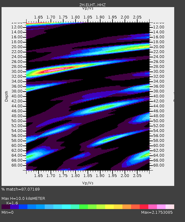
ELHT Mt Erebus site ELHT - Earthquake Result Viewer
| Earthquake location: |
South Sandwich Islands Region |
| Earthquake latitude/longitude: |
-58.1/-25.2 |
| Earthquake time(UTC): |
2018/11/01 (305) 19:30:20 GMT |
| Earthquake Depth: |
29 km |
| Earthquake Magnitude: |
5.8 Mww |
| Earthquake Catalog/Contributor: |
NEIC PDE/us |
|
| Network: |
2H Interim Broadband Monitoring of the Mount Erebus Volcano |
| Station: |
ELHT Mt Erebus site ELHT |
| Lat/Lon: |
77.51 S/167.14 E |
| Elevation: |
3375 m |
|
| Distance: |
44.5 deg |
| Az: |
183.811 deg |
| Baz: |
170.66 deg |
| Ray Param: |
0.071856335 |
| Estimated Moho Depth: |
10.0 km |
| Estimated Crust Vp/Vs: |
1.60 |
| Assumed Crust Vp: |
6.183 km/s |
| Estimated Crust Vs: |
3.864 km/s |
| Estimated Crust Poisson's Ratio: |
0.18 |
|
| Radial Match: |
87.07169 % |
| Radial Bump: |
400 |
| Transverse Match: |
74.61441 % |
| Transverse Bump: |
400 |
| SOD ConfigId: |
13570011 |
| Insert Time: |
2019-05-01 16:57:35.382 +0000 |
| GWidth: |
2.5 |
| Max Bumps: |
400 |
| Tol: |
0.001 |
|

Signal To Noise
| Channel | StoN | STA | LTA |
| 2H:ELHT: :HHZ:20181101T19:37:58.674009Z | 8.735409 | 9.0669755E-7 | 1.03795664E-7 |
| 2H:ELHT: :HH1:20181101T19:37:58.674009Z | 3.9711485 | 6.464723E-7 | 1.6279228E-7 |
| 2H:ELHT: :HH2:20181101T19:37:58.674009Z | 1.7094023 | 2.1016943E-7 | 1.2294907E-7 |
| Arrivals |
| Ps | 1.0 SECOND |
| PpPs | 3.9 SECOND |
| PsPs/PpSs | 5.0 SECOND |


