You are here: Home > Network List > XW17 - Broadband seismic experiment in NE Uganda to investigate plume-lithosphere inter Stations List
> Station GULU Bungatira Sub-County Offices > Earthquake Result Viewer
GULU Bungatira Sub-County Offices - Earthquake Result Viewer
| Earthquake location: |
South Sandwich Islands Region |
| Earthquake latitude/longitude: |
-58.1/-25.2 |
| Earthquake time(UTC): |
2018/11/01 (305) 19:30:20 GMT |
| Earthquake Depth: |
29 km |
| Earthquake Magnitude: |
5.8 Mww |
| Earthquake Catalog/Contributor: |
NEIC PDE/us |
|
| Network: |
XW Broadband seismic experiment in NE Uganda to investigate plume-lithosphere inter |
| Station: |
GULU Bungatira Sub-County Offices |
| Lat/Lon: |
2.88 N/32.28 E |
| Elevation: |
1059 m |
|
| Distance: |
75.9 deg |
| Az: |
60.259 deg |
| Baz: |
207.514 deg |
| Ray Param: |
0.05129301 |
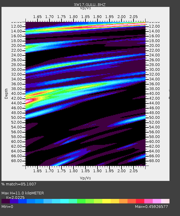
| Estimated Moho Depth: |
11.0 km |
| Estimated Crust Vp/Vs: |
2.02 |
| Assumed Crust Vp: |
6.642 km/s |
| Estimated Crust Vs: |
3.284 km/s |
| Estimated Crust Poisson's Ratio: |
0.34 |
|
| Radial Match: |
85.1807 % |
| Radial Bump: |
400 |
| Transverse Match: |
81.1465 % |
| Transverse Bump: |
400 |
| SOD ConfigId: |
13570011 |
| Insert Time: |
2019-05-01 17:00:01.641 +0000 |
| GWidth: |
2.5 |
| Max Bumps: |
400 |
| Tol: |
0.001 |
|

Signal To Noise
| Channel | StoN | STA | LTA |
| XW:GULU: :BHZ:20181101T19:41:33.83502Z | 11.532352 | 8.9381257E-7 | 7.750479E-8 |
| XW:GULU: :BHN:20181101T19:41:33.83502Z | 7.1142893 | 3.4479396E-7 | 4.846499E-8 |
| XW:GULU: :BHE:20181101T19:41:33.83502Z | 3.0657077 | 1.2328294E-7 | 4.0213532E-8 |
| Arrivals |
| Ps | 1.7 SECOND |
| PpPs | 4.9 SECOND |
| PsPs/PpSs | 6.6 SECOND |


