You are here: Home > Network List > TA - USArray Transportable Network (new EarthScope stations) Stations List
> Station Y20A Horse Springs, Datil, NM, USA > Earthquake Result Viewer
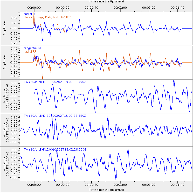
Y20A Horse Springs, Datil, NM, USA - Earthquake Result Viewer
*The percent match for this event was below the threshold and hence no stack was calculated.
| Earthquake location: |
Near Coast Of Peru |
| Earthquake latitude/longitude: |
-13.6/-76.6 |
| Earthquake time(UTC): |
2009/02/02 (033) 17:53:21 GMT |
| Earthquake Depth: |
21 km |
| Earthquake Magnitude: |
5.6 MB, 5.6 MS, 6.0 MW, 5.9 MW |
| Earthquake Catalog/Contributor: |
WHDF/NEIC |
|
| Network: |
TA USArray Transportable Network (new EarthScope stations) |
| Station: |
Y20A Horse Springs, Datil, NM, USA |
| Lat/Lon: |
33.91 N/108.38 W |
| Elevation: |
2177 m |
|
| Distance: |
56.1 deg |
| Az: |
328.115 deg |
| Baz: |
141.859 deg |
| Ray Param: |
$rayparam |
*The percent match for this event was below the threshold and hence was not used in the summary stack. |
|
| Radial Match: |
57.5013 % |
| Radial Bump: |
323 |
| Transverse Match: |
36.35467 % |
| Transverse Bump: |
292 |
| SOD ConfigId: |
6627 |
| Insert Time: |
2010-03-06 17:23:19.302 +0000 |
| GWidth: |
2.5 |
| Max Bumps: |
400 |
| Tol: |
0.001 |
|
Signal To Noise
| Channel | StoN | STA | LTA |
| TA:Y20A: :BHZ:20090202T18:02:28.550Z | 2.3778145 | 3.5877466E-7 | 1.5088422E-7 |
| TA:Y20A: :BHN:20090202T18:02:28.550Z | 1.1552945 | 2.5311812E-7 | 2.19094E-7 |
| TA:Y20A: :BHE:20090202T18:02:28.550Z | 0.57400185 | 1.515322E-7 | 2.6399255E-7 |
| Arrivals |
| Ps | |
| PpPs | |
| PsPs/PpSs | |


