You are here: Home > Network List > TA - USArray Transportable Network (new EarthScope stations) Stations List
> Station 121A Cookes Peak, Deming, NM, USA > Earthquake Result Viewer
121A Cookes Peak, Deming, NM, USA - Earthquake Result Viewer

| Earthquake location: |
Tonga Islands |
| Earthquake latitude/longitude: |
-15.1/-173.5 |
| Earthquake time(UTC): |
2008/08/19 (232) 16:30:13 GMT |
| Earthquake Depth: |
8.0 km |
| Earthquake Magnitude: |
5.6 MB, 5.9 MS, 6.1 MW, 6.0 MW |
| Earthquake Catalog/Contributor: |
WHDF/NEIC |
|
| Network: |
TA USArray Transportable Network (new EarthScope stations) |
| Station: |
121A Cookes Peak, Deming, NM, USA |
| Lat/Lon: |
32.53 N/107.79 W |
| Elevation: |
1652 m |
|
| Distance: |
78.6 deg |
| Az: |
51.747 deg |
| Baz: |
243.897 deg |
| Ray Param: |
0.049527198 |
| Estimated Moho Depth: |
48.75 km |
| Estimated Crust Vp/Vs: |
1.99 |
| Assumed Crust Vp: |
6.502 km/s |
| Estimated Crust Vs: |
3.267 km/s |
| Estimated Crust Poisson's Ratio: |
0.33 |
|
| Radial Match: |
86.53709 % |
| Radial Bump: |
400 |
| Transverse Match: |
79.02598 % |
| Transverse Bump: |
400 |
| SOD ConfigId: |
2504 |
| Insert Time: |
2010-03-06 17:23:40.495 +0000 |
| GWidth: |
2.5 |
| Max Bumps: |
400 |
| Tol: |
0.001 |
|
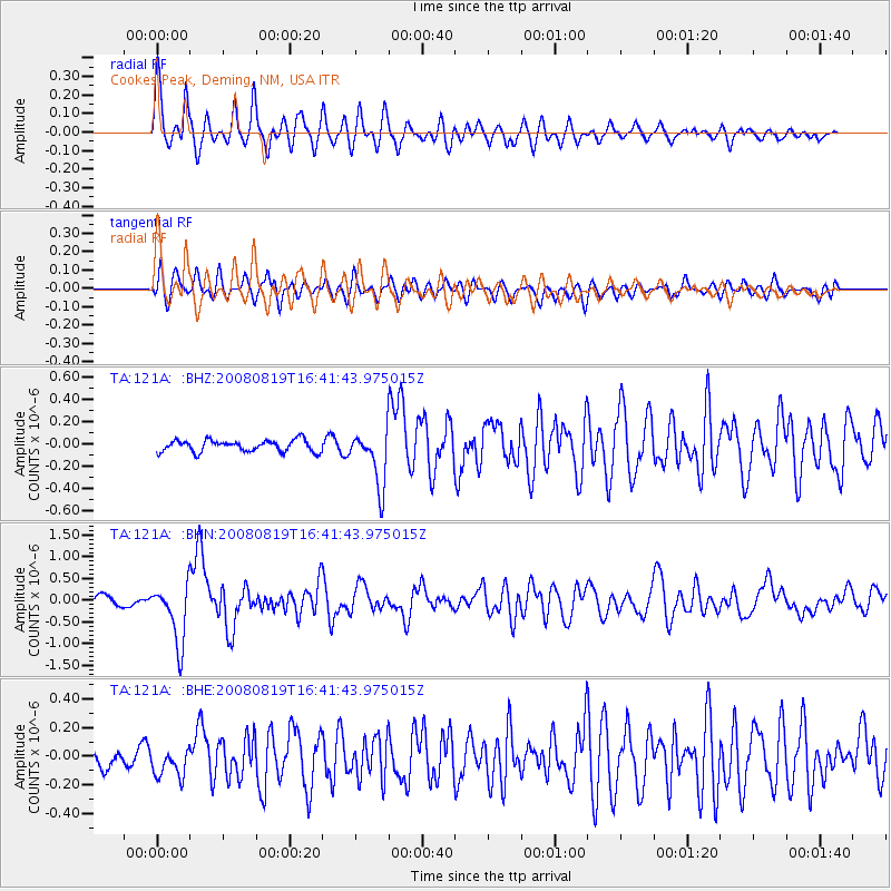
Signal To Noise
| Channel | StoN | STA | LTA |
| TA:121A: :BHN:20080819T16:41:43.975015Z | 8.15653 | 6.85318E-7 | 8.4020776E-8 |
| TA:121A: :BHE:20080819T16:41:43.975015Z | 1.5536153 | 1.02521994E-7 | 6.5989305E-8 |
| TA:121A: :BHZ:20080819T16:41:43.975015Z | 4.8853064 | 2.515799E-7 | 5.1497263E-8 |
| Arrivals |
| Ps | 7.6 SECOND |
| PpPs | 22 SECOND |
| PsPs/PpSs | 29 SECOND |


