You are here: Home > Network List > TS - TERRAscope (Southern California Seismic Network) Stations List
> Station BAR Barrett Dam, California, USA > Earthquake Result Viewer
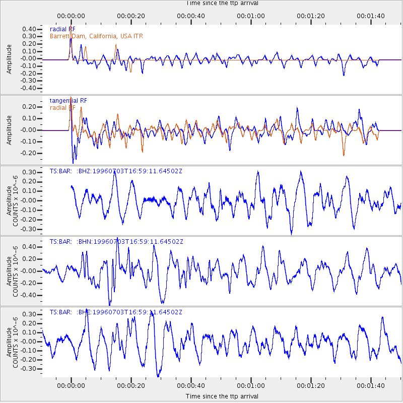
BAR Barrett Dam, California, USA - Earthquake Result Viewer
*The percent match for this event was below the threshold and hence no stack was calculated.
| Earthquake location: |
Near Coast Of Northern Chile |
| Earthquake latitude/longitude: |
-23.4/-70.4 |
| Earthquake time(UTC): |
1996/07/03 (185) 16:48:27 GMT |
| Earthquake Depth: |
33 km |
| Earthquake Magnitude: |
5.3 MB, 5.4 MS, 5.8 UNKNOWN |
| Earthquake Catalog/Contributor: |
WHDF/NEIC |
|
| Network: |
TS TERRAscope (Southern California Seismic Network) |
| Station: |
BAR Barrett Dam, California, USA |
| Lat/Lon: |
32.68 N/116.67 W |
| Elevation: |
548 m |
|
| Distance: |
71.1 deg |
| Az: |
319.906 deg |
| Baz: |
135.433 deg |
| Ray Param: |
$rayparam |
*The percent match for this event was below the threshold and hence was not used in the summary stack. |
|
| Radial Match: |
63.61357 % |
| Radial Bump: |
400 |
| Transverse Match: |
73.93873 % |
| Transverse Bump: |
400 |
| SOD ConfigId: |
4480 |
| Insert Time: |
2010-02-26 13:59:48.740 +0000 |
| GWidth: |
2.5 |
| Max Bumps: |
400 |
| Tol: |
0.001 |
|
Signal To Noise
| Channel | StoN | STA | LTA |
| TS:BAR: :BHN:19960703T16:59:11.64502Z | 0.8334071 | 1.0949679E-7 | 1.3138452E-7 |
| TS:BAR: :BHE:19960703T16:59:11.64502Z | 0.915751 | 1.0061475E-7 | 1.09871294E-7 |
| TS:BAR: :BHZ:19960703T16:59:11.64502Z | 0.5592575 | 6.816849E-8 | 1.2189105E-7 |
| Arrivals |
| Ps | |
| PpPs | |
| PsPs/PpSs | |


