You are here: Home > Network List > TA - USArray Transportable Network (new EarthScope stations) Stations List
> Station 121A Cookes Peak, Deming, NM, USA > Earthquake Result Viewer
121A Cookes Peak, Deming, NM, USA - Earthquake Result Viewer

| Earthquake location: |
Off Coast Of Costa Rica |
| Earthquake latitude/longitude: |
7.9/-85.6 |
| Earthquake time(UTC): |
2009/08/13 (225) 09:37:35 GMT |
| Earthquake Depth: |
10 km |
| Earthquake Magnitude: |
5.8 MW, 5.3 MB |
| Earthquake Catalog/Contributor: |
WHDF/NEIC |
|
| Network: |
TA USArray Transportable Network (new EarthScope stations) |
| Station: |
121A Cookes Peak, Deming, NM, USA |
| Lat/Lon: |
32.53 N/107.79 W |
| Elevation: |
1652 m |
|
| Distance: |
32.0 deg |
| Az: |
322.999 deg |
| Baz: |
135.113 deg |
| Ray Param: |
0.07885742 |
| Estimated Moho Depth: |
23.75 km |
| Estimated Crust Vp/Vs: |
2.10 |
| Assumed Crust Vp: |
6.502 km/s |
| Estimated Crust Vs: |
3.1 km/s |
| Estimated Crust Poisson's Ratio: |
0.35 |
|
| Radial Match: |
90.9554 % |
| Radial Bump: |
400 |
| Transverse Match: |
68.28734 % |
| Transverse Bump: |
400 |
| SOD ConfigId: |
2622 |
| Insert Time: |
2010-03-06 17:24:18.293 +0000 |
| GWidth: |
2.5 |
| Max Bumps: |
400 |
| Tol: |
0.001 |
|
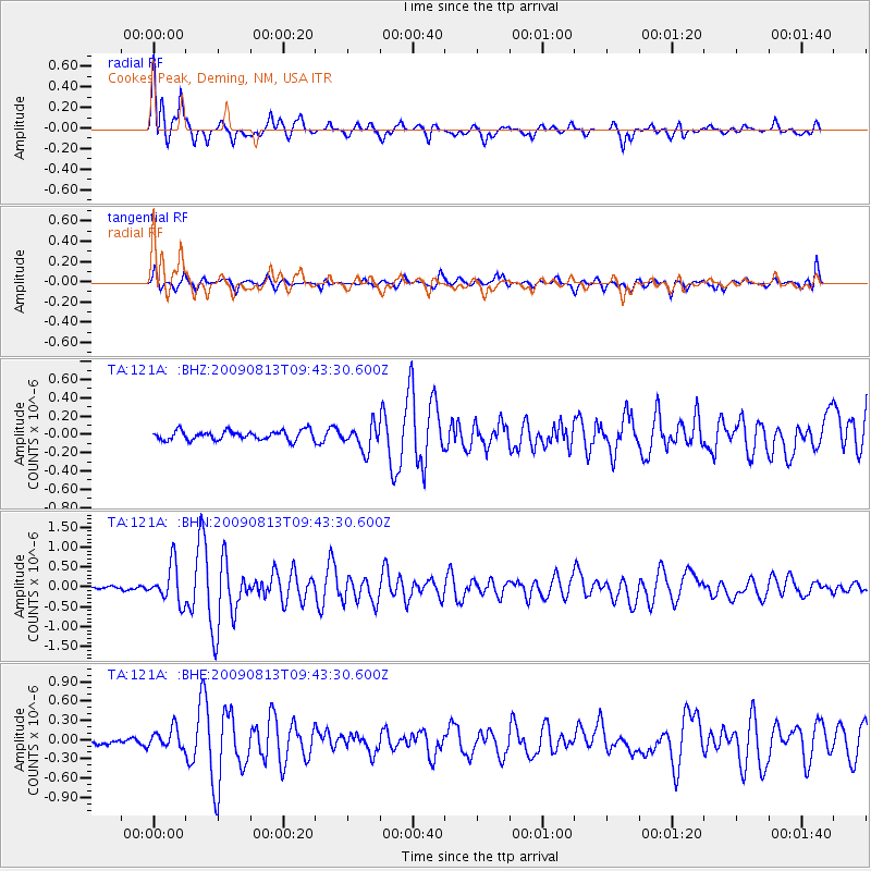
Signal To Noise
| Channel | StoN | STA | LTA |
| TA:121A: :BHN:20090813T09:43:30.600Z | 7.322156 | 4.786173E-7 | 6.5365626E-8 |
| TA:121A: :BHE:20090813T09:43:30.600Z | 2.412483 | 1.564393E-7 | 6.4845764E-8 |
| TA:121A: :BHZ:20090813T09:43:30.600Z | 2.6538901 | 1.351215E-7 | 5.0914505E-8 |
| Arrivals |
| Ps | 4.3 SECOND |
| PpPs | 11 SECOND |
| PsPs/PpSs | 15 SECOND |


