You are here: Home > Network List > N4 - Central and EAstern US Network Stations List
> Station M52A Chesterland, OH, USA > Earthquake Result Viewer
M52A Chesterland, OH, USA - Earthquake Result Viewer
| Earthquake location: |
Northern Chile |
| Earthquake latitude/longitude: |
-19.6/-69.3 |
| Earthquake time(UTC): |
2018/11/01 (305) 22:19:51 GMT |
| Earthquake Depth: |
102 km |
| Earthquake Magnitude: |
6.2 Mww |
| Earthquake Catalog/Contributor: |
NEIC PDE/us |
|
| Network: |
N4 Central and EAstern US Network |
| Station: |
M52A Chesterland, OH, USA |
| Lat/Lon: |
41.54 N/81.36 W |
| Elevation: |
382 m |
|
| Distance: |
61.8 deg |
| Az: |
349.748 deg |
| Baz: |
167.083 deg |
| Ray Param: |
0.060335983 |
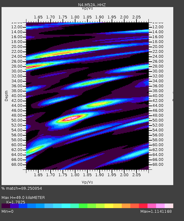
| Estimated Moho Depth: |
49.0 km |
| Estimated Crust Vp/Vs: |
1.78 |
| Assumed Crust Vp: |
6.483 km/s |
| Estimated Crust Vs: |
3.637 km/s |
| Estimated Crust Poisson's Ratio: |
0.27 |
|
| Radial Match: |
89.250854 % |
| Radial Bump: |
400 |
| Transverse Match: |
76.32842 % |
| Transverse Bump: |
400 |
| SOD ConfigId: |
13570011 |
| Insert Time: |
2019-05-01 17:06:16.423 +0000 |
| GWidth: |
2.5 |
| Max Bumps: |
400 |
| Tol: |
0.001 |
|

Signal To Noise
| Channel | StoN | STA | LTA |
| N4:M52A: :HHZ:20181101T22:29:29.130027Z | 14.962168 | 2.9417001E-6 | 1.9660922E-7 |
| N4:M52A: :HHN:20181101T22:29:29.130027Z | 7.7258043 | 1.7381752E-6 | 2.2498308E-7 |
| N4:M52A: :HHE:20181101T22:29:29.130027Z | 2.793899 | 4.4264792E-7 | 1.5843375E-7 |
| Arrivals |
| Ps | 6.2 SECOND |
| PpPs | 20 SECOND |
| PsPs/PpSs | 26 SECOND |


