You are here: Home > Network List > OK - Oklahoma Seismic Network Stations List
> Station NOKA Waynoka, Oklahoma, USA > Earthquake Result Viewer
NOKA Waynoka, Oklahoma, USA - Earthquake Result Viewer
| Earthquake location: |
Northern Chile |
| Earthquake latitude/longitude: |
-19.6/-69.3 |
| Earthquake time(UTC): |
2018/11/01 (305) 22:19:51 GMT |
| Earthquake Depth: |
102 km |
| Earthquake Magnitude: |
6.2 Mww |
| Earthquake Catalog/Contributor: |
NEIC PDE/us |
|
| Network: |
OK Oklahoma Seismic Network |
| Station: |
NOKA Waynoka, Oklahoma, USA |
| Lat/Lon: |
36.63 N/98.93 W |
| Elevation: |
476 m |
|
| Distance: |
62.5 deg |
| Az: |
333.365 deg |
| Baz: |
148.299 deg |
| Ray Param: |
0.05988065 |
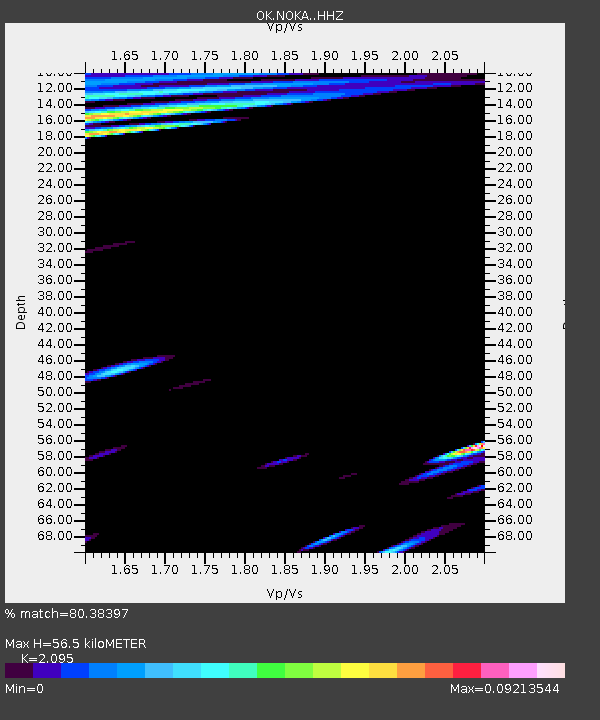
| Estimated Moho Depth: |
56.5 km |
| Estimated Crust Vp/Vs: |
2.10 |
| Assumed Crust Vp: |
6.426 km/s |
| Estimated Crust Vs: |
3.067 km/s |
| Estimated Crust Poisson's Ratio: |
0.35 |
|
| Radial Match: |
80.38397 % |
| Radial Bump: |
335 |
| Transverse Match: |
65.63687 % |
| Transverse Bump: |
400 |
| SOD ConfigId: |
13570011 |
| Insert Time: |
2019-05-01 17:08:35.463 +0000 |
| GWidth: |
2.5 |
| Max Bumps: |
400 |
| Tol: |
0.001 |
|

Signal To Noise
| Channel | StoN | STA | LTA |
| OK:NOKA: :HHZ:20181101T22:29:33.803977Z | 4.9544587 | 2.8034467E-6 | 5.6584315E-7 |
| OK:NOKA: :HHN:20181101T22:29:33.803977Z | 4.228724 | 1.1455064E-6 | 2.70887E-7 |
| OK:NOKA: :HHE:20181101T22:29:33.803977Z | 2.0059679 | 1.1343219E-6 | 5.6547367E-7 |
| Arrivals |
| Ps | 10.0 SECOND |
| PpPs | 26 SECOND |
| PsPs/PpSs | 36 SECOND |


