You are here: Home > Network List > TA - USArray Transportable Network (new EarthScope stations) Stations List
> Station 121A Cookes Peak, Deming, NM, USA > Earthquake Result Viewer
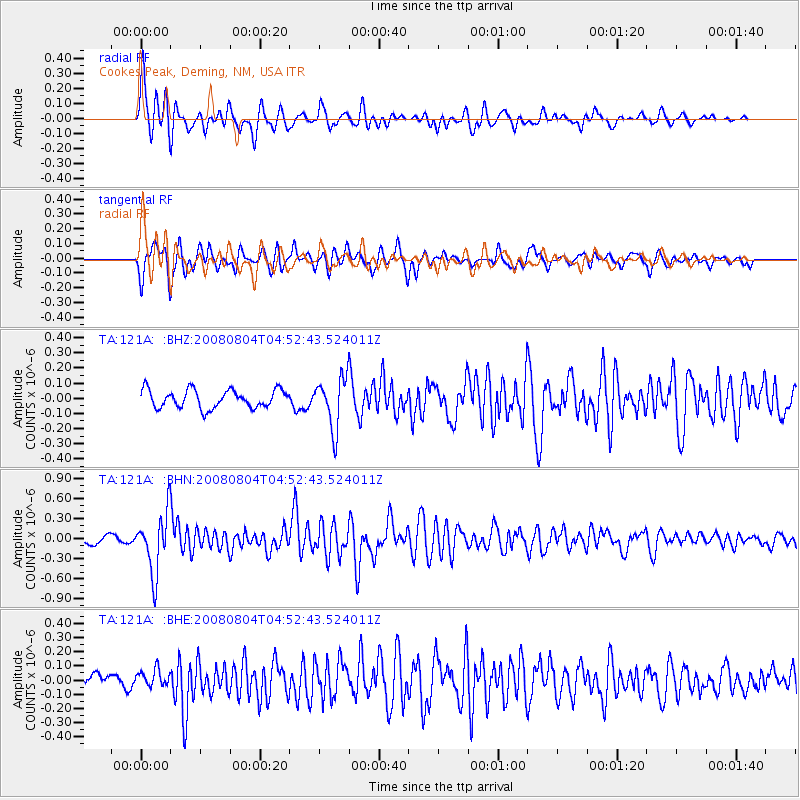
121A Cookes Peak, Deming, NM, USA - Earthquake Result Viewer
*The percent match for this event was below the threshold and hence no stack was calculated.
| Earthquake location: |
Kuril Islands |
| Earthquake latitude/longitude: |
49.9/156.4 |
| Earthquake time(UTC): |
2008/08/04 (217) 04:42:14 GMT |
| Earthquake Depth: |
77 km |
| Earthquake Magnitude: |
5.6 MB, 5.8 MW, 5.7 MW |
| Earthquake Catalog/Contributor: |
WHDF/NEIC |
|
| Network: |
TA USArray Transportable Network (new EarthScope stations) |
| Station: |
121A Cookes Peak, Deming, NM, USA |
| Lat/Lon: |
32.53 N/107.79 W |
| Elevation: |
1652 m |
|
| Distance: |
69.4 deg |
| Az: |
63.888 deg |
| Baz: |
316.522 deg |
| Ray Param: |
$rayparam |
*The percent match for this event was below the threshold and hence was not used in the summary stack. |
|
| Radial Match: |
71.72992 % |
| Radial Bump: |
400 |
| Transverse Match: |
73.82472 % |
| Transverse Bump: |
400 |
| SOD ConfigId: |
2504 |
| Insert Time: |
2010-03-06 17:25:35.319 +0000 |
| GWidth: |
2.5 |
| Max Bumps: |
400 |
| Tol: |
0.001 |
|
Signal To Noise
| Channel | StoN | STA | LTA |
| TA:121A: :BHN:20080804T04:52:43.524011Z | 7.3919435 | 4.469448E-7 | 6.0463776E-8 |
| TA:121A: :BHE:20080804T04:52:43.524011Z | 1.2178425 | 5.838871E-8 | 4.7944386E-8 |
| TA:121A: :BHZ:20080804T04:52:43.524011Z | 2.8010216 | 1.6858397E-7 | 6.01866E-8 |
| Arrivals |
| Ps | |
| PpPs | |
| PsPs/PpSs | |


