You are here: Home > Network List > TA - USArray Transportable Network (new EarthScope stations) Stations List
> Station H31M Peel River, Yukon, CAN > Earthquake Result Viewer
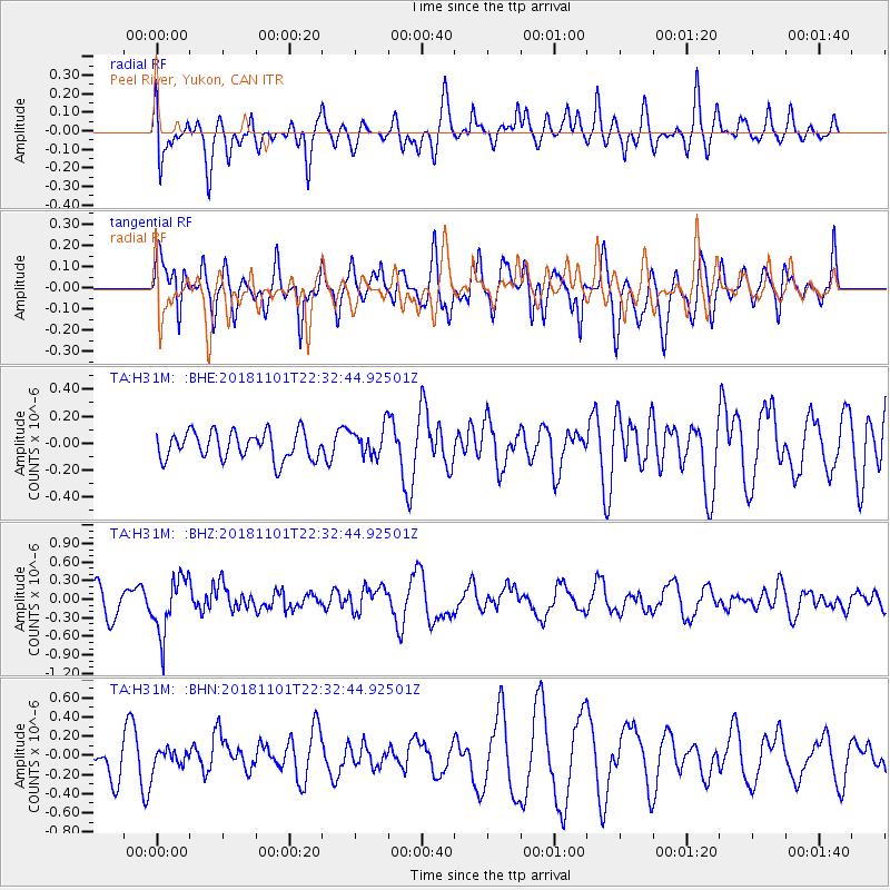
H31M Peel River, Yukon, CAN - Earthquake Result Viewer
*The percent match for this event was below the threshold and hence no stack was calculated.
| Earthquake location: |
Northern Chile |
| Earthquake latitude/longitude: |
-19.6/-69.3 |
| Earthquake time(UTC): |
2018/11/01 (305) 22:19:51 GMT |
| Earthquake Depth: |
102 km |
| Earthquake Magnitude: |
6.2 Mww |
| Earthquake Catalog/Contributor: |
NEIC PDE/us |
|
| Network: |
TA USArray Transportable Network (new EarthScope stations) |
| Station: |
H31M Peel River, Yukon, CAN |
| Lat/Lon: |
65.81 N/134.34 W |
| Elevation: |
642 m |
|
| Distance: |
98.0 deg |
| Az: |
337.829 deg |
| Baz: |
120.309 deg |
| Ray Param: |
$rayparam |
*The percent match for this event was below the threshold and hence was not used in the summary stack. |
|
| Radial Match: |
72.404465 % |
| Radial Bump: |
400 |
| Transverse Match: |
59.374332 % |
| Transverse Bump: |
400 |
| SOD ConfigId: |
13570011 |
| Insert Time: |
2019-05-01 17:10:22.805 +0000 |
| GWidth: |
2.5 |
| Max Bumps: |
400 |
| Tol: |
0.001 |
|
Signal To Noise
| Channel | StoN | STA | LTA |
| TA:H31M: :BHZ:20181101T22:32:44.92501Z | 2.3459444 | 4.5715714E-7 | 1.9487125E-7 |
| TA:H31M: :BHN:20181101T22:32:44.92501Z | 0.38031322 | 9.7353194E-8 | 2.559816E-7 |
| TA:H31M: :BHE:20181101T22:32:44.92501Z | 1.0535553 | 1.07156524E-7 | 1.01709446E-7 |
| Arrivals |
| Ps | |
| PpPs | |
| PsPs/PpSs | |


