You are here: Home > Network List > TA - USArray Transportable Network (new EarthScope stations) Stations List
> Station 121A Cookes Peak, Deming, NM, USA > Earthquake Result Viewer
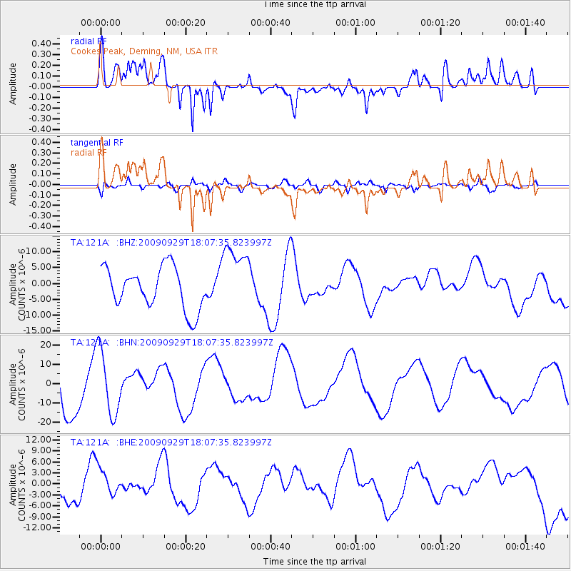
121A Cookes Peak, Deming, NM, USA - Earthquake Result Viewer
*The percent match for this event was below the threshold and hence no stack was calculated.
| Earthquake location: |
Tonga Islands |
| Earthquake latitude/longitude: |
-15.4/-173.2 |
| Earthquake time(UTC): |
2009/09/29 (272) 17:56:05 GMT |
| Earthquake Depth: |
10 km |
| Earthquake Magnitude: |
6.0 MB |
| Earthquake Catalog/Contributor: |
WHDF/NEIC |
|
| Network: |
TA USArray Transportable Network (new EarthScope stations) |
| Station: |
121A Cookes Peak, Deming, NM, USA |
| Lat/Lon: |
32.53 N/107.79 W |
| Elevation: |
1652 m |
|
| Distance: |
78.5 deg |
| Az: |
51.584 deg |
| Baz: |
243.49 deg |
| Ray Param: |
$rayparam |
*The percent match for this event was below the threshold and hence was not used in the summary stack. |
|
| Radial Match: |
66.97078 % |
| Radial Bump: |
400 |
| Transverse Match: |
41.519672 % |
| Transverse Bump: |
400 |
| SOD ConfigId: |
2622 |
| Insert Time: |
2010-03-06 17:25:54.140 +0000 |
| GWidth: |
2.5 |
| Max Bumps: |
400 |
| Tol: |
0.001 |
|
Signal To Noise
| Channel | StoN | STA | LTA |
| TA:121A: :BHN:20090929T18:07:35.823997Z | 1.7736179 | 1.6547416E-5 | 9.329752E-6 |
| TA:121A: :BHE:20090929T18:07:35.823997Z | 1.25151 | 3.5651358E-6 | 2.8486675E-6 |
| TA:121A: :BHZ:20090929T18:07:35.823997Z | 1.6510172 | 1.0727874E-5 | 6.497736E-6 |
| Arrivals |
| Ps | |
| PpPs | |
| PsPs/PpSs | |


