You are here: Home > Network List > US - United States National Seismic Network Stations List
> Station GLMI Grayling, Michigan, USA > Earthquake Result Viewer
GLMI Grayling, Michigan, USA - Earthquake Result Viewer
| Earthquake location: |
Sakhalin, Russia |
| Earthquake latitude/longitude: |
50.4/142.3 |
| Earthquake time(UTC): |
2016/08/14 (227) 11:15:14 GMT |
| Earthquake Depth: |
5.8 km |
| Earthquake Magnitude: |
5.7 MWW, 5.7 MWB, 5.8 MWC |
| Earthquake Catalog/Contributor: |
NEIC PDE/NEIC COMCAT |
|
| Network: |
US United States National Seismic Network |
| Station: |
GLMI Grayling, Michigan, USA |
| Lat/Lon: |
44.82 N/84.62 W |
| Elevation: |
387 m |
|
| Distance: |
76.7 deg |
| Az: |
32.276 deg |
| Baz: |
331.319 deg |
| Ray Param: |
0.050792508 |
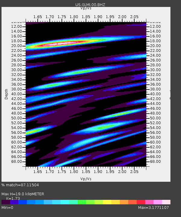
| Estimated Moho Depth: |
19.0 km |
| Estimated Crust Vp/Vs: |
1.73 |
| Assumed Crust Vp: |
6.483 km/s |
| Estimated Crust Vs: |
3.747 km/s |
| Estimated Crust Poisson's Ratio: |
0.25 |
|
| Radial Match: |
87.11504 % |
| Radial Bump: |
400 |
| Transverse Match: |
78.05992 % |
| Transverse Bump: |
400 |
| SOD ConfigId: |
1634031 |
| Insert Time: |
2016-08-28 11:21:20.922 +0000 |
| GWidth: |
2.5 |
| Max Bumps: |
400 |
| Tol: |
0.001 |
|

Signal To Noise
| Channel | StoN | STA | LTA |
| US:GLMI:00:BHZ:20160814T11:26:34.874026Z | 4.8613563 | 1.7540659E-6 | 3.608182E-7 |
| US:GLMI:00:BH1:20160814T11:26:34.874026Z | 3.9763584 | 1.2358768E-6 | 3.1080617E-7 |
| US:GLMI:00:BH2:20160814T11:26:34.874026Z | 1.6763002 | 7.2563563E-7 | 4.3287926E-7 |
| Arrivals |
| Ps | 2.2 SECOND |
| PpPs | 7.7 SECOND |
| PsPs/PpSs | 10.0 SECOND |


