You are here: Home > Network List > TA - USArray Transportable Network (new EarthScope stations) Stations List
> Station 121A Cookes Peak, Deming, NM, USA > Earthquake Result Viewer
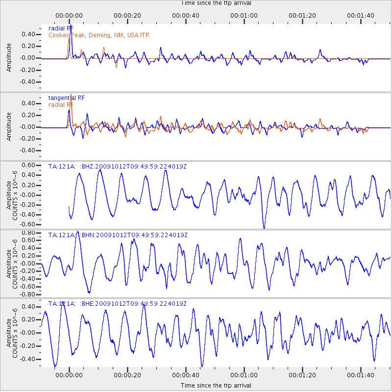
121A Cookes Peak, Deming, NM, USA - Earthquake Result Viewer
*The percent match for this event was below the threshold and hence no stack was calculated.
| Earthquake location: |
Santa Cruz Islands |
| Earthquake latitude/longitude: |
-12.4/166.5 |
| Earthquake time(UTC): |
2009/10/12 (285) 09:37:21 GMT |
| Earthquake Depth: |
42 km |
| Earthquake Magnitude: |
5.9 MB, 5.9 MS, 6.2 MW, 6.2 MW |
| Earthquake Catalog/Contributor: |
WHDF/NEIC |
|
| Network: |
TA USArray Transportable Network (new EarthScope stations) |
| Station: |
121A Cookes Peak, Deming, NM, USA |
| Lat/Lon: |
32.53 N/107.79 W |
| Elevation: |
1652 m |
|
| Distance: |
93.0 deg |
| Az: |
57.515 deg |
| Baz: |
257.303 deg |
| Ray Param: |
$rayparam |
*The percent match for this event was below the threshold and hence was not used in the summary stack. |
|
| Radial Match: |
67.35752 % |
| Radial Bump: |
400 |
| Transverse Match: |
50.98366 % |
| Transverse Bump: |
400 |
| SOD ConfigId: |
2622 |
| Insert Time: |
2010-03-06 17:26:01.977 +0000 |
| GWidth: |
2.5 |
| Max Bumps: |
400 |
| Tol: |
0.001 |
|
Signal To Noise
| Channel | StoN | STA | LTA |
| TA:121A: :BHN:20091012T09:49:59.224019Z | 1.9958687 | 4.390359E-7 | 2.1997232E-7 |
| TA:121A: :BHE:20091012T09:49:59.224019Z | 1.2521888 | 2.1761218E-7 | 1.7378544E-7 |
| TA:121A: :BHZ:20091012T09:49:59.224019Z | 1.036938 | 2.9853143E-7 | 2.8789708E-7 |
| Arrivals |
| Ps | |
| PpPs | |
| PsPs/PpSs | |


