You are here: Home > Network List > TA - USArray Transportable Network (new EarthScope stations) Stations List
> Station V17A Tonalea, Kykotsmovi, AZ, USA > Earthquake Result Viewer
V17A Tonalea, Kykotsmovi, AZ, USA - Earthquake Result Viewer
| Earthquake location: |
Southern Peru |
| Earthquake latitude/longitude: |
-16.0/-71.7 |
| Earthquake time(UTC): |
2008/07/08 (190) 09:13:07 GMT |
| Earthquake Depth: |
123 km |
| Earthquake Magnitude: |
5.8 MB, 6.2 MW, 6.2 MW |
| Earthquake Catalog/Contributor: |
WHDF/NEIC |
|
| Network: |
TA USArray Transportable Network (new EarthScope stations) |
| Station: |
V17A Tonalea, Kykotsmovi, AZ, USA |
| Lat/Lon: |
35.62 N/110.79 W |
| Elevation: |
1596 m |
|
| Distance: |
63.3 deg |
| Az: |
324.923 deg |
| Baz: |
137.28 deg |
| Ray Param: |
0.059343494 |
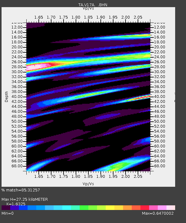
| Estimated Moho Depth: |
27.25 km |
| Estimated Crust Vp/Vs: |
1.63 |
| Assumed Crust Vp: |
6.207 km/s |
| Estimated Crust Vs: |
3.802 km/s |
| Estimated Crust Poisson's Ratio: |
0.20 |
|
| Radial Match: |
85.31257 % |
| Radial Bump: |
374 |
| Transverse Match: |
66.46294 % |
| Transverse Bump: |
360 |
| SOD ConfigId: |
2504 |
| Insert Time: |
2010-03-06 17:27:13.766 +0000 |
| GWidth: |
2.5 |
| Max Bumps: |
400 |
| Tol: |
0.001 |
|

Signal To Noise
| Channel | StoN | STA | LTA |
| TA:V17A: :BHN:20080708T09:22:52.249001Z | 6.7349553 | 5.829448E-7 | 8.655511E-8 |
| TA:V17A: :BHE:20080708T09:22:52.249001Z | 2.2162352 | 1.2292983E-7 | 5.546787E-8 |
| TA:V17A: :BHZ:20080708T09:22:52.249001Z | 1.6741253 | 1.3944589E-7 | 8.329477E-8 |
| Arrivals |
| Ps | 2.9 SECOND |
| PpPs | 11 SECOND |
| PsPs/PpSs | 14 SECOND |


