You are here: Home > Network List > CI - Caltech Regional Seismic Network Stations List
> Station TIN Tinemaha, Big Pine, CA, USA > Earthquake Result Viewer
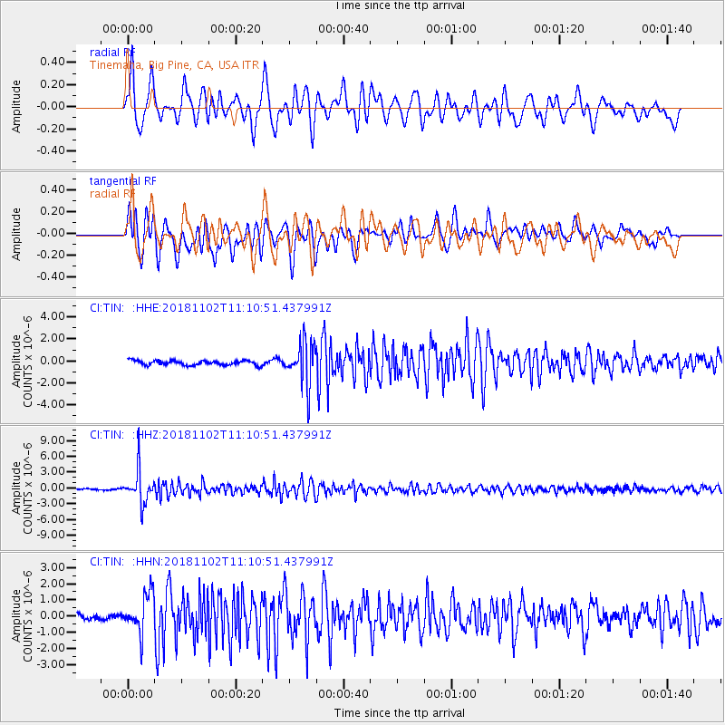
TIN Tinemaha, Big Pine, CA, USA - Earthquake Result Viewer
*The percent match for this event was below the threshold and hence no stack was calculated.
| Earthquake location: |
Northwest Of Kuril Islands |
| Earthquake latitude/longitude: |
47.8/146.7 |
| Earthquake time(UTC): |
2018/11/02 (306) 11:01:15 GMT |
| Earthquake Depth: |
432 km |
| Earthquake Magnitude: |
5.9 Mww |
| Earthquake Catalog/Contributor: |
NEIC PDE/us |
|
| Network: |
CI Caltech Regional Seismic Network |
| Station: |
TIN Tinemaha, Big Pine, CA, USA |
| Lat/Lon: |
37.05 N/118.23 W |
| Elevation: |
1197 m |
|
| Distance: |
66.7 deg |
| Az: |
60.198 deg |
| Baz: |
313.025 deg |
| Ray Param: |
$rayparam |
*The percent match for this event was below the threshold and hence was not used in the summary stack. |
|
| Radial Match: |
74.987366 % |
| Radial Bump: |
400 |
| Transverse Match: |
75.48059 % |
| Transverse Bump: |
400 |
| SOD ConfigId: |
13570011 |
| Insert Time: |
2019-05-01 17:19:12.724 +0000 |
| GWidth: |
2.5 |
| Max Bumps: |
400 |
| Tol: |
0.001 |
|
Signal To Noise
| Channel | StoN | STA | LTA |
| CI:TIN: :HHZ:20181102T11:10:51.437991Z | 20.624128 | 3.182976E-6 | 1.5433262E-7 |
| CI:TIN: :HHN:20181102T11:10:51.437991Z | 5.674659 | 1.2242243E-6 | 2.1573533E-7 |
| CI:TIN: :HHE:20181102T11:10:51.437991Z | 9.390131 | 1.9644337E-6 | 2.0920194E-7 |
| Arrivals |
| Ps | |
| PpPs | |
| PsPs/PpSs | |


