You are here: Home > Network List > TA - USArray Transportable Network (new EarthScope stations) Stations List
> Station V17A Tonalea, Kykotsmovi, AZ, USA > Earthquake Result Viewer
V17A Tonalea, Kykotsmovi, AZ, USA - Earthquake Result Viewer

| Earthquake location: |
Peru-Brazil Border Region |
| Earthquake latitude/longitude: |
-7.6/-74.4 |
| Earthquake time(UTC): |
2008/08/26 (239) 21:00:36 GMT |
| Earthquake Depth: |
154 km |
| Earthquake Magnitude: |
6.0 MB, 6.4 MW, 6.4 MW |
| Earthquake Catalog/Contributor: |
WHDF/NEIC |
|
| Network: |
TA USArray Transportable Network (new EarthScope stations) |
| Station: |
V17A Tonalea, Kykotsmovi, AZ, USA |
| Lat/Lon: |
35.62 N/110.79 W |
| Elevation: |
1596 m |
|
| Distance: |
55.0 deg |
| Az: |
323.822 deg |
| Baz: |
134.095 deg |
| Ray Param: |
0.06456038 |
| Estimated Moho Depth: |
27.5 km |
| Estimated Crust Vp/Vs: |
2.08 |
| Assumed Crust Vp: |
6.207 km/s |
| Estimated Crust Vs: |
2.988 km/s |
| Estimated Crust Poisson's Ratio: |
0.35 |
|
| Radial Match: |
94.68546 % |
| Radial Bump: |
298 |
| Transverse Match: |
83.677536 % |
| Transverse Bump: |
305 |
| SOD ConfigId: |
2504 |
| Insert Time: |
2010-03-06 17:27:24.641 +0000 |
| GWidth: |
2.5 |
| Max Bumps: |
400 |
| Tol: |
0.001 |
|
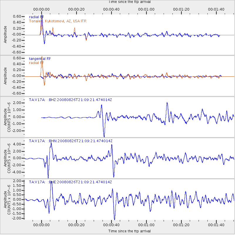
Signal To Noise
| Channel | StoN | STA | LTA |
| TA:V17A: :BHN:20080826T21:09:21.474014Z | 21.538208 | 1.9190543E-6 | 8.909999E-8 |
| TA:V17A: :BHE:20080826T21:09:21.474014Z | 4.4177604 | 5.3320093E-7 | 1.2069486E-7 |
| TA:V17A: :BHZ:20080826T21:09:21.474014Z | 13.490014 | 6.8407076E-7 | 5.0709417E-8 |
| Arrivals |
| Ps | 5.0 SECOND |
| PpPs | 13 SECOND |
| PsPs/PpSs | 18 SECOND |


