You are here: Home > Network List > TA - USArray Transportable Network (new EarthScope stations) Stations List
> Station V17A Tonalea, Kykotsmovi, AZ, USA > Earthquake Result Viewer
V17A Tonalea, Kykotsmovi, AZ, USA - Earthquake Result Viewer
| Earthquake location: |
Virgin Islands |
| Earthquake latitude/longitude: |
19.2/-64.8 |
| Earthquake time(UTC): |
2008/10/11 (285) 10:40:14 GMT |
| Earthquake Depth: |
23 km |
| Earthquake Magnitude: |
6.1 MB, 5.9 MS, 6.1 MW, 6.0 MW |
| Earthquake Catalog/Contributor: |
WHDF/NEIC |
|
| Network: |
TA USArray Transportable Network (new EarthScope stations) |
| Station: |
V17A Tonalea, Kykotsmovi, AZ, USA |
| Lat/Lon: |
35.62 N/110.79 W |
| Elevation: |
1596 m |
|
| Distance: |
43.6 deg |
| Az: |
301.814 deg |
| Baz: |
99.623 deg |
| Ray Param: |
0.072431326 |
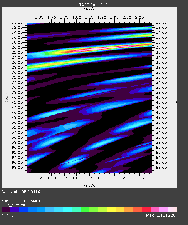
| Estimated Moho Depth: |
20.0 km |
| Estimated Crust Vp/Vs: |
1.91 |
| Assumed Crust Vp: |
6.207 km/s |
| Estimated Crust Vs: |
3.245 km/s |
| Estimated Crust Poisson's Ratio: |
0.31 |
|
| Radial Match: |
85.18419 % |
| Radial Bump: |
375 |
| Transverse Match: |
73.17649 % |
| Transverse Bump: |
378 |
| SOD ConfigId: |
2556 |
| Insert Time: |
2010-03-06 17:27:28.278 +0000 |
| GWidth: |
2.5 |
| Max Bumps: |
400 |
| Tol: |
0.001 |
|
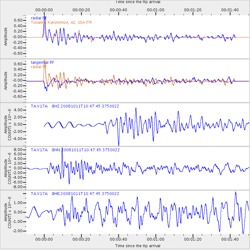
Signal To Noise
| Channel | StoN | STA | LTA |
| TA:V17A: :BHN:20081011T10:47:45.375002Z | 2.539118 | 9.759765E-7 | 3.8437616E-7 |
| TA:V17A: :BHE:20081011T10:47:45.375002Z | 0.39285097 | 2.314947E-7 | 5.892685E-7 |
| TA:V17A: :BHZ:20081011T10:47:45.375002Z | 1.7796022 | 8.7538484E-7 | 4.918992E-7 |
| Arrivals |
| Ps | 3.1 SECOND |
| PpPs | 8.9 SECOND |
| PsPs/PpSs | 12 SECOND |


