You are here: Home > Network List > TA - USArray Transportable Network (new EarthScope stations) Stations List
> Station V17A Tonalea, Kykotsmovi, AZ, USA > Earthquake Result Viewer
V17A Tonalea, Kykotsmovi, AZ, USA - Earthquake Result Viewer
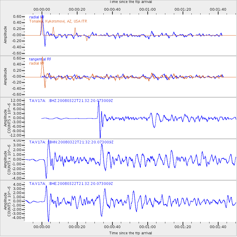
| Earthquake location: |
Andreanof Islands, Aleutian Is. |
| Earthquake latitude/longitude: |
52.2/-178.7 |
| Earthquake time(UTC): |
2008/03/22 (082) 21:24:11 GMT |
| Earthquake Depth: |
132 km |
| Earthquake Magnitude: |
5.8 MB, 6.2 MW, 6.1 MW |
| Earthquake Catalog/Contributor: |
WHDF/NEIC |
|
| Network: |
TA USArray Transportable Network (new EarthScope stations) |
| Station: |
V17A Tonalea, Kykotsmovi, AZ, USA |
| Lat/Lon: |
35.62 N/110.79 W |
| Elevation: |
1596 m |
|
| Distance: |
49.8 deg |
| Az: |
81.28 deg |
| Baz: |
311.659 deg |
| Ray Param: |
0.068018 |
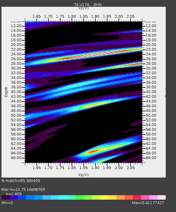
| Estimated Moho Depth: |
23.75 km |
| Estimated Crust Vp/Vs: |
1.90 |
| Assumed Crust Vp: |
6.207 km/s |
| Estimated Crust Vs: |
3.258 km/s |
| Estimated Crust Poisson's Ratio: |
0.31 |
|
| Radial Match: |
95.388405 % |
| Radial Bump: |
321 |
| Transverse Match: |
78.77241 % |
| Transverse Bump: |
400 |
| SOD ConfigId: |
2564 |
| Insert Time: |
2010-03-06 17:27:41.018 +0000 |
| GWidth: |
2.5 |
| Max Bumps: |
400 |
| Tol: |
0.001 |
|
Signal To Noise
| Channel | StoN | STA | LTA |
| TA:V17A: :BHN:20080322T21:32:20.073009Z | 11.5028105 | 1.9743925E-6 | 1.7164434E-7 |
| TA:V17A: :BHE:20080322T21:32:20.073009Z | 7.5566382 | 2.0995685E-6 | 2.7784424E-7 |
| TA:V17A: :BHZ:20080322T21:32:20.073009Z | 26.308449 | 5.447636E-6 | 2.0706793E-7 |
| Arrivals |
| Ps | 3.6 SECOND |
| PpPs | 11 SECOND |
| PsPs/PpSs | 14 SECOND |


