You are here: Home > Network List > TA - USArray Transportable Network (new EarthScope stations) Stations List
> Station V17A Tonalea, Kykotsmovi, AZ, USA > Earthquake Result Viewer
V17A Tonalea, Kykotsmovi, AZ, USA - Earthquake Result Viewer
| Earthquake location: |
Santa Cruz Islands Region |
| Earthquake latitude/longitude: |
-11.0/164.5 |
| Earthquake time(UTC): |
2008/07/19 (201) 09:27:01 GMT |
| Earthquake Depth: |
11 km |
| Earthquake Magnitude: |
6.1 MB, 6.4 MS, 6.6 MW, 6.6 MW |
| Earthquake Catalog/Contributor: |
WHDF/NEIC |
|
| Network: |
TA USArray Transportable Network (new EarthScope stations) |
| Station: |
V17A Tonalea, Kykotsmovi, AZ, USA |
| Lat/Lon: |
35.62 N/110.79 W |
| Elevation: |
1596 m |
|
| Distance: |
92.1 deg |
| Az: |
54.273 deg |
| Baz: |
258.017 deg |
| Ray Param: |
0.04150916 |
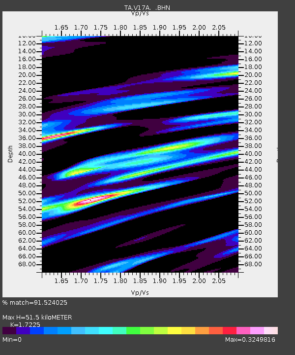
| Estimated Moho Depth: |
51.5 km |
| Estimated Crust Vp/Vs: |
1.72 |
| Assumed Crust Vp: |
6.207 km/s |
| Estimated Crust Vs: |
3.603 km/s |
| Estimated Crust Poisson's Ratio: |
0.25 |
|
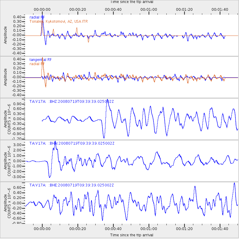
| Radial Match: |
91.524025 % |
| Radial Bump: |
400 |
| Transverse Match: |
77.12688 % |
| Transverse Bump: |
400 |
| SOD ConfigId: |
2658 |
| Insert Time: |
2010-03-06 17:27:47.408 +0000 |
| GWidth: |
2.5 |
| Max Bumps: |
400 |
| Tol: |
0.001 |
|
Signal To Noise
| Channel | StoN | STA | LTA |
| TA:V17A: :BHN:20080719T09:39:39.025002Z | 18.304771 | 1.351921E-6 | 7.385621E-8 |
| TA:V17A: :BHE:20080719T09:39:39.025002Z | 2.0571377 | 1.1298529E-7 | 5.492354E-8 |
| TA:V17A: :BHZ:20080719T09:39:39.025002Z | 3.6617312 | 3.8725588E-7 | 1.0575759E-7 |
| Arrivals |
| Ps | 6.1 SECOND |
| PpPs | 22 SECOND |
| PsPs/PpSs | 28 SECOND |


