You are here: Home > Network List > TA - USArray Transportable Network (new EarthScope stations) Stations List
> Station V17A Tonalea, Kykotsmovi, AZ, USA > Earthquake Result Viewer
V17A Tonalea, Kykotsmovi, AZ, USA - Earthquake Result Viewer
| Earthquake location: |
Panama-Costa Rica Border Region |
| Earthquake latitude/longitude: |
8.3/-83.0 |
| Earthquake time(UTC): |
2008/11/19 (324) 06:11:20 GMT |
| Earthquake Depth: |
32 km |
| Earthquake Magnitude: |
5.9 MB, 5.9 MS, 6.2 MW, 6.1 MW |
| Earthquake Catalog/Contributor: |
WHDF/NEIC |
|
| Network: |
TA USArray Transportable Network (new EarthScope stations) |
| Station: |
V17A Tonalea, Kykotsmovi, AZ, USA |
| Lat/Lon: |
35.62 N/110.79 W |
| Elevation: |
1596 m |
|
| Distance: |
37.3 deg |
| Az: |
321.079 deg |
| Baz: |
130.253 deg |
| Ray Param: |
0.076177604 |
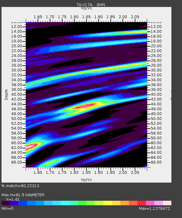
| Estimated Moho Depth: |
61.5 km |
| Estimated Crust Vp/Vs: |
1.61 |
| Assumed Crust Vp: |
6.207 km/s |
| Estimated Crust Vs: |
3.855 km/s |
| Estimated Crust Poisson's Ratio: |
0.19 |
|
| Radial Match: |
90.22313 % |
| Radial Bump: |
306 |
| Transverse Match: |
56.60273 % |
| Transverse Bump: |
400 |
| SOD ConfigId: |
2658 |
| Insert Time: |
2010-03-06 17:27:56.932 +0000 |
| GWidth: |
2.5 |
| Max Bumps: |
400 |
| Tol: |
0.001 |
|

Signal To Noise
| Channel | StoN | STA | LTA |
| TA:V17A: :BHN:20081119T06:17:59.05001Z | 3.7709582 | 3.8352363E-7 | 1.0170455E-7 |
| TA:V17A: :BHE:20081119T06:17:59.05001Z | 0.8678777 | 1.6326521E-7 | 1.8812005E-7 |
| TA:V17A: :BHZ:20081119T06:17:59.05001Z | 0.9329058 | 1.3053692E-7 | 1.3992508E-7 |
| Arrivals |
| Ps | 6.5 SECOND |
| PpPs | 24 SECOND |
| PsPs/PpSs | 30 SECOND |


