You are here: Home > Network List > TA - USArray Transportable Network (new EarthScope stations) Stations List
> Station V17A Tonalea, Kykotsmovi, AZ, USA > Earthquake Result Viewer
V17A Tonalea, Kykotsmovi, AZ, USA - Earthquake Result Viewer
| Earthquake location: |
Near Coast Of Central Chile |
| Earthquake latitude/longitude: |
-32.5/-71.7 |
| Earthquake time(UTC): |
2008/12/18 (353) 21:19:28 GMT |
| Earthquake Depth: |
18 km |
| Earthquake Magnitude: |
5.8 MB, 6.0 MS, 6.2 MW, 6.1 MW |
| Earthquake Catalog/Contributor: |
WHDF/NEIC |
|
| Network: |
TA USArray Transportable Network (new EarthScope stations) |
| Station: |
V17A Tonalea, Kykotsmovi, AZ, USA |
| Lat/Lon: |
35.62 N/110.79 W |
| Elevation: |
1596 m |
|
| Distance: |
77.0 deg |
| Az: |
328.198 deg |
| Baz: |
146.849 deg |
| Ray Param: |
0.050606467 |
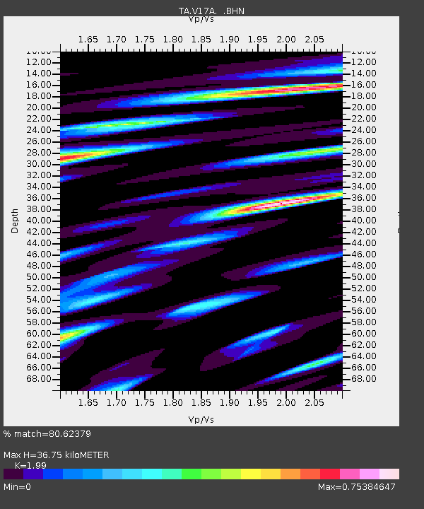
| Estimated Moho Depth: |
36.75 km |
| Estimated Crust Vp/Vs: |
1.99 |
| Assumed Crust Vp: |
6.207 km/s |
| Estimated Crust Vs: |
3.119 km/s |
| Estimated Crust Poisson's Ratio: |
0.33 |
|
| Radial Match: |
80.62379 % |
| Radial Bump: |
400 |
| Transverse Match: |
61.57938 % |
| Transverse Bump: |
400 |
| SOD ConfigId: |
2658 |
| Insert Time: |
2010-03-06 17:28:01.112 +0000 |
| GWidth: |
2.5 |
| Max Bumps: |
400 |
| Tol: |
0.001 |
|
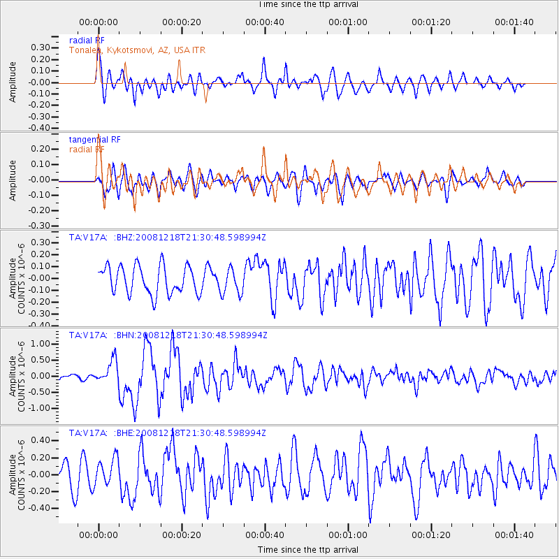
Signal To Noise
| Channel | StoN | STA | LTA |
| TA:V17A: :BHN:20081218T21:30:48.598994Z | 4.4340105 | 3.7457104E-7 | 8.44768E-8 |
| TA:V17A: :BHE:20081218T21:30:48.598994Z | 1.242039 | 1.5885377E-7 | 1.2789758E-7 |
| TA:V17A: :BHZ:20081218T21:30:48.598994Z | 0.91123664 | 1.0689137E-7 | 1.17303635E-7 |
| Arrivals |
| Ps | 6.0 SECOND |
| PpPs | 17 SECOND |
| PsPs/PpSs | 23 SECOND |


