You are here: Home > Network List > TA - USArray Transportable Network (new EarthScope stations) Stations List
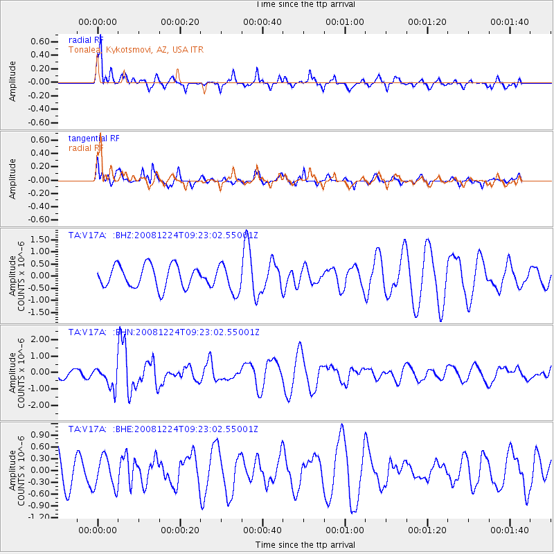
> Station V17A Tonalea, Kykotsmovi, AZ, USA > Earthquake Result Viewer
V17A Tonalea, Kykotsmovi, AZ, USA - Earthquake Result Viewer
| Earthquake location: |
Tonga Islands Region |
| Earthquake latitude/longitude: |
-17.3/-171.9 |
| Earthquake time(UTC): |
2008/12/24 (359) 09:11:34 GMT |
| Earthquake Depth: |
9.0 km |
| Earthquake Magnitude: |
5.9 MB, 5.6 MS, 6.0 MW, 6.0 MW |
| Earthquake Catalog/Contributor: |
WHDF/NEIC |
|
| Network: |
TA USArray Transportable Network (new EarthScope stations) |
| Station: |
V17A Tonalea, Kykotsmovi, AZ, USA |
| Lat/Lon: |
35.62 N/110.79 W |
| Elevation: |
1596 m |
|
| Distance: |
78.2 deg |
| Az: |
46.786 deg |
| Baz: |
238.718 deg |
| Ray Param: |
0.049813956 |
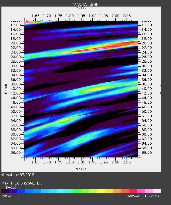
| Estimated Moho Depth: |
10.5 km |
| Estimated Crust Vp/Vs: |
1.60 |
| Assumed Crust Vp: |
6.207 km/s |
| Estimated Crust Vs: |
3.879 km/s |
| Estimated Crust Poisson's Ratio: |
0.18 |
|
| Radial Match: |
87.0815 % |
| Radial Bump: |
398 |
| Transverse Match: |
54.04593 % |
| Transverse Bump: |
325 |
| SOD ConfigId: |
2658 |
| Insert Time: |
2010-03-06 17:28:03.087 +0000 |
| GWidth: |
2.5 |
| Max Bumps: |
400 |
| Tol: |
0.001 |
|
Signal To Noise
| Channel | StoN | STA | LTA |
| TA:V17A: :BHN:20081224T09:23:02.55001Z | 3.0333805 | 6.6518E-7 | 2.192867E-7 |
| TA:V17A: :BHE:20081224T09:23:02.55001Z | 0.66586864 | 3.9325909E-7 | 5.905956E-7 |
| TA:V17A: :BHZ:20081224T09:23:02.55001Z | 1.3040868 | 5.9275226E-7 | 4.5453436E-7 |
| Arrivals |
| Ps | 1.0 SECOND |
| PpPs | 4.3 SECOND |
| PsPs/PpSs | 5.3 SECOND |


