You are here: Home > Network List > LD - Lamont-Doherty Cooperative Seismographic Network Stations List
> Station MVL Millersville University, PA > Earthquake Result Viewer
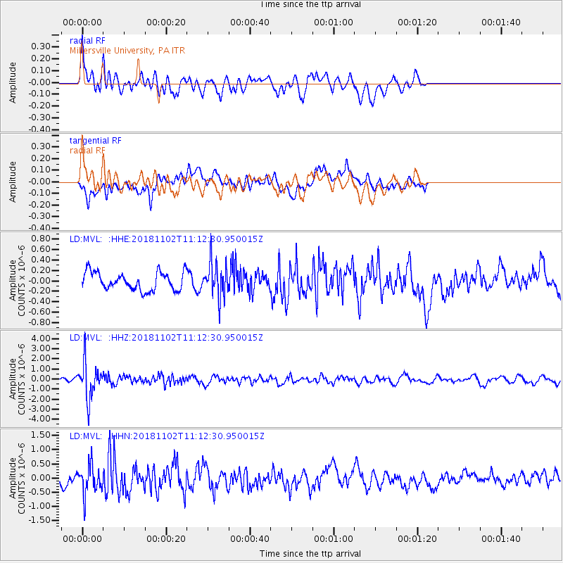
MVL Millersville University, PA - Earthquake Result Viewer
*The percent match for this event was below the threshold and hence no stack was calculated.
| Earthquake location: |
Northwest Of Kuril Islands |
| Earthquake latitude/longitude: |
47.8/146.7 |
| Earthquake time(UTC): |
2018/11/02 (306) 11:01:15 GMT |
| Earthquake Depth: |
432 km |
| Earthquake Magnitude: |
5.9 Mww |
| Earthquake Catalog/Contributor: |
NEIC PDE/us |
|
| Network: |
LD Lamont-Doherty Cooperative Seismographic Network |
| Station: |
MVL Millersville University, PA |
| Lat/Lon: |
40.00 N/76.35 W |
| Elevation: |
91 m |
|
| Distance: |
84.6 deg |
| Az: |
31.799 deg |
| Baz: |
332.463 deg |
| Ray Param: |
$rayparam |
*The percent match for this event was below the threshold and hence was not used in the summary stack. |
|
| Radial Match: |
57.060432 % |
| Radial Bump: |
400 |
| Transverse Match: |
63.184742 % |
| Transverse Bump: |
400 |
| SOD ConfigId: |
13570011 |
| Insert Time: |
2019-05-01 17:22:25.133 +0000 |
| GWidth: |
2.5 |
| Max Bumps: |
400 |
| Tol: |
0.001 |
|
Signal To Noise
| Channel | StoN | STA | LTA |
| LD:MVL: :HHZ:20181102T11:12:30.950015Z | 10.948113 | 1.8216522E-6 | 1.663896E-7 |
| LD:MVL: :HHN:20181102T11:12:30.950015Z | 2.8593228 | 5.063305E-7 | 1.7708055E-7 |
| LD:MVL: :HHE:20181102T11:12:30.950015Z | 1.9544755 | 3.3542472E-7 | 1.716188E-7 |
| Arrivals |
| Ps | |
| PpPs | |
| PsPs/PpSs | |


