You are here: Home > Network List > TA - USArray Transportable Network (new EarthScope stations) Stations List
> Station V17A Tonalea, Kykotsmovi, AZ, USA > Earthquake Result Viewer
V17A Tonalea, Kykotsmovi, AZ, USA - Earthquake Result Viewer

| Earthquake location: |
Andreanof Islands, Aleutian Is. |
| Earthquake latitude/longitude: |
51.9/-179.4 |
| Earthquake time(UTC): |
2008/04/15 (106) 22:59:51 GMT |
| Earthquake Depth: |
10 km |
| Earthquake Magnitude: |
6.1 MB, 6.4 MS, 6.4 MW, 6.4 MW |
| Earthquake Catalog/Contributor: |
WHDF/NEIC |
|
| Network: |
TA USArray Transportable Network (new EarthScope stations) |
| Station: |
V17A Tonalea, Kykotsmovi, AZ, USA |
| Lat/Lon: |
35.62 N/110.79 W |
| Elevation: |
1596 m |
|
| Distance: |
50.2 deg |
| Az: |
80.561 deg |
| Baz: |
311.326 deg |
| Ray Param: |
0.06818706 |
| Estimated Moho Depth: |
64.25 km |
| Estimated Crust Vp/Vs: |
1.91 |
| Assumed Crust Vp: |
6.207 km/s |
| Estimated Crust Vs: |
3.254 km/s |
| Estimated Crust Poisson's Ratio: |
0.31 |
|
| Radial Match: |
96.90709 % |
| Radial Bump: |
331 |
| Transverse Match: |
87.24168 % |
| Transverse Bump: |
400 |
| SOD ConfigId: |
2504 |
| Insert Time: |
2010-03-06 17:28:04.838 +0000 |
| GWidth: |
2.5 |
| Max Bumps: |
400 |
| Tol: |
0.001 |
|
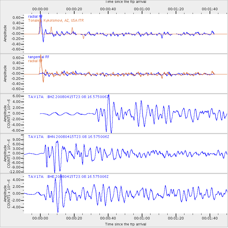
Signal To Noise
| Channel | StoN | STA | LTA |
| TA:V17A: :BHN:20080415T23:08:16.575006Z | 12.421016 | 3.1996105E-6 | 2.5759653E-7 |
| TA:V17A: :BHE:20080415T23:08:16.575006Z | 3.3059433 | 1.0457038E-6 | 3.163103E-7 |
| TA:V17A: :BHZ:20080415T23:08:16.575006Z | 3.7526953 | 1.0336873E-6 | 2.7545195E-7 |
| Arrivals |
| Ps | 9.9 SECOND |
| PpPs | 29 SECOND |
| PsPs/PpSs | 39 SECOND |


