You are here: Home > Network List > TA - USArray Transportable Network (new EarthScope stations) Stations List
> Station V17A Tonalea, Kykotsmovi, AZ, USA > Earthquake Result Viewer
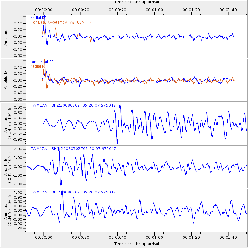
V17A Tonalea, Kykotsmovi, AZ, USA - Earthquake Result Viewer
*The percent match for this event was below the threshold and hence no stack was calculated.
| Earthquake location: |
Andreanof Islands, Aleutian Is. |
| Earthquake latitude/longitude: |
51.9/-179.3 |
| Earthquake time(UTC): |
2008/03/02 (062) 05:11:44 GMT |
| Earthquake Depth: |
21 km |
| Earthquake Magnitude: |
5.6 MS, 5.4 MB, 5.8 MW, 5.7 MW |
| Earthquake Catalog/Contributor: |
WHDF/NEIC |
|
| Network: |
TA USArray Transportable Network (new EarthScope stations) |
| Station: |
V17A Tonalea, Kykotsmovi, AZ, USA |
| Lat/Lon: |
35.62 N/110.79 W |
| Elevation: |
1596 m |
|
| Distance: |
50.2 deg |
| Az: |
80.596 deg |
| Baz: |
311.326 deg |
| Ray Param: |
$rayparam |
*The percent match for this event was below the threshold and hence was not used in the summary stack. |
|
| Radial Match: |
79.103546 % |
| Radial Bump: |
340 |
| Transverse Match: |
63.44509 % |
| Transverse Bump: |
400 |
| SOD ConfigId: |
2504 |
| Insert Time: |
2010-03-06 17:28:25.357 +0000 |
| GWidth: |
2.5 |
| Max Bumps: |
400 |
| Tol: |
0.001 |
|
Signal To Noise
| Channel | StoN | STA | LTA |
| TA:V17A: :BHN:20080302T05:20:07.97501Z | 3.007217 | 4.1760754E-7 | 1.3886844E-7 |
| TA:V17A: :BHE:20080302T05:20:07.97501Z | 1.4912608 | 2.1887212E-7 | 1.4676985E-7 |
| TA:V17A: :BHZ:20080302T05:20:07.97501Z | 1.2874355 | 2.1787582E-7 | 1.6923242E-7 |
| Arrivals |
| Ps | |
| PpPs | |
| PsPs/PpSs | |


