You are here: Home > Network List > TA - USArray Transportable Network (new EarthScope stations) Stations List
> Station V17A Tonalea, Kykotsmovi, AZ, USA > Earthquake Result Viewer
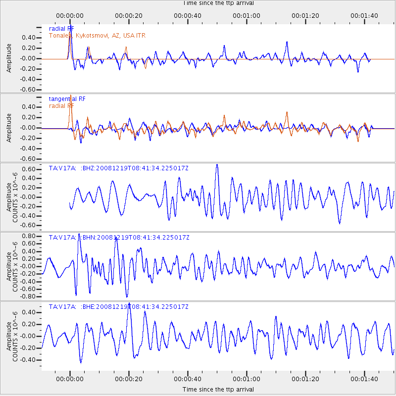
V17A Tonalea, Kykotsmovi, AZ, USA - Earthquake Result Viewer
*The percent match for this event was below the threshold and hence no stack was calculated.
| Earthquake location: |
Northern Mid-Atlantic Ridge |
| Earthquake latitude/longitude: |
47.0/-27.3 |
| Earthquake time(UTC): |
2008/12/19 (354) 08:31:51 GMT |
| Earthquake Depth: |
2.0 km |
| Earthquake Magnitude: |
5.8 MB, 5.6 MS, 5.9 MW, 5.8 MW |
| Earthquake Catalog/Contributor: |
WHDF/NEIC |
|
| Network: |
TA USArray Transportable Network (new EarthScope stations) |
| Station: |
V17A Tonalea, Kykotsmovi, AZ, USA |
| Lat/Lon: |
35.62 N/110.79 W |
| Elevation: |
1596 m |
|
| Distance: |
60.9 deg |
| Az: |
292.159 deg |
| Baz: |
51.081 deg |
| Ray Param: |
$rayparam |
*The percent match for this event was below the threshold and hence was not used in the summary stack. |
|
| Radial Match: |
77.94831 % |
| Radial Bump: |
366 |
| Transverse Match: |
59.946808 % |
| Transverse Bump: |
400 |
| SOD ConfigId: |
2658 |
| Insert Time: |
2010-03-06 17:29:04.696 +0000 |
| GWidth: |
2.5 |
| Max Bumps: |
400 |
| Tol: |
0.001 |
|
Signal To Noise
| Channel | StoN | STA | LTA |
| TA:V17A: :BHN:20081219T08:41:34.225017Z | 4.321611 | 3.9945047E-7 | 9.243092E-8 |
| TA:V17A: :BHE:20081219T08:41:34.225017Z | 1.3957908 | 1.9358882E-7 | 1.3869472E-7 |
| TA:V17A: :BHZ:20081219T08:41:34.225017Z | 1.3058089 | 2.3025207E-7 | 1.7632907E-7 |
| Arrivals |
| Ps | |
| PpPs | |
| PsPs/PpSs | |


