You are here: Home > Network List > TA - USArray Transportable Network (new EarthScope stations) Stations List
> Station V17A Tonalea, Kykotsmovi, AZ, USA > Earthquake Result Viewer
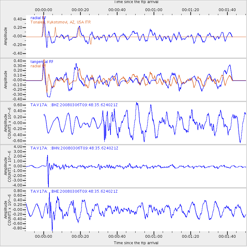
V17A Tonalea, Kykotsmovi, AZ, USA - Earthquake Result Viewer
*The percent match for this event was below the threshold and hence no stack was calculated.
| Earthquake location: |
Kamchatka Peninsula, Russia |
| Earthquake latitude/longitude: |
51.5/156.5 |
| Earthquake time(UTC): |
2008/03/06 (066) 09:38:43 GMT |
| Earthquake Depth: |
134 km |
| Earthquake Magnitude: |
5.6 MB, 5.5 MW, 5.5 MW |
| Earthquake Catalog/Contributor: |
WHDF/NEIC |
|
| Network: |
TA USArray Transportable Network (new EarthScope stations) |
| Station: |
V17A Tonalea, Kykotsmovi, AZ, USA |
| Lat/Lon: |
35.62 N/110.79 W |
| Elevation: |
1596 m |
|
| Distance: |
64.6 deg |
| Az: |
64.293 deg |
| Baz: |
316.294 deg |
| Ray Param: |
$rayparam |
*The percent match for this event was below the threshold and hence was not used in the summary stack. |
|
| Radial Match: |
60.612537 % |
| Radial Bump: |
400 |
| Transverse Match: |
47.47321 % |
| Transverse Bump: |
400 |
| SOD ConfigId: |
2504 |
| Insert Time: |
2010-03-06 17:29:08.600 +0000 |
| GWidth: |
2.5 |
| Max Bumps: |
400 |
| Tol: |
0.001 |
|
Signal To Noise
| Channel | StoN | STA | LTA |
| TA:V17A: :BHN:20080306T09:48:35.624021Z | 7.0686226 | 1.1334347E-6 | 1.6034733E-7 |
| TA:V17A: :BHE:20080306T09:48:35.624021Z | 1.1474223 | 3.2927875E-7 | 2.869726E-7 |
| TA:V17A: :BHZ:20080306T09:48:35.624021Z | 1.2933383 | 2.4052792E-7 | 1.8597447E-7 |
| Arrivals |
| Ps | |
| PpPs | |
| PsPs/PpSs | |


