You are here: Home > Network List > TA - USArray Transportable Network (new EarthScope stations) Stations List
> Station G31M Satah River, YT, CAN > Earthquake Result Viewer
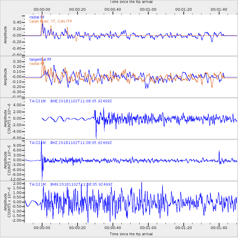
G31M Satah River, YT, CAN - Earthquake Result Viewer
*The percent match for this event was below the threshold and hence no stack was calculated.
| Earthquake location: |
Northwest Of Kuril Islands |
| Earthquake latitude/longitude: |
47.8/146.7 |
| Earthquake time(UTC): |
2018/11/02 (306) 11:01:15 GMT |
| Earthquake Depth: |
432 km |
| Earthquake Magnitude: |
5.9 Mww |
| Earthquake Catalog/Contributor: |
NEIC PDE/us |
|
| Network: |
TA USArray Transportable Network (new EarthScope stations) |
| Station: |
G31M Satah River, YT, CAN |
| Lat/Lon: |
66.92 N/134.27 W |
| Elevation: |
61 m |
|
| Distance: |
43.1 deg |
| Az: |
34.46 deg |
| Baz: |
284.666 deg |
| Ray Param: |
$rayparam |
*The percent match for this event was below the threshold and hence was not used in the summary stack. |
|
| Radial Match: |
49.81154 % |
| Radial Bump: |
400 |
| Transverse Match: |
64.77611 % |
| Transverse Bump: |
400 |
| SOD ConfigId: |
13570011 |
| Insert Time: |
2019-05-01 17:28:38.396 +0000 |
| GWidth: |
2.5 |
| Max Bumps: |
400 |
| Tol: |
0.001 |
|
Signal To Noise
| Channel | StoN | STA | LTA |
| TA:G31M: :BHZ:20181102T11:08:05.92499Z | 13.466265 | 3.5233736E-6 | 2.6164446E-7 |
| TA:G31M: :BHN:20181102T11:08:05.92499Z | 2.1023147 | 6.7911003E-7 | 3.230297E-7 |
| TA:G31M: :BHE:20181102T11:08:05.92499Z | 4.140985 | 1.5888326E-6 | 3.836847E-7 |
| Arrivals |
| Ps | |
| PpPs | |
| PsPs/PpSs | |


