You are here: Home > Network List > TA - USArray Transportable Network (new EarthScope stations) Stations List
> Station I17K Unalakleet, AK, USA > Earthquake Result Viewer
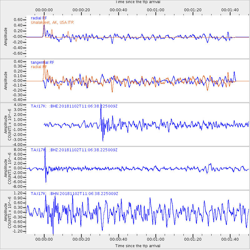
I17K Unalakleet, AK, USA - Earthquake Result Viewer
*The percent match for this event was below the threshold and hence no stack was calculated.
| Earthquake location: |
Northwest Of Kuril Islands |
| Earthquake latitude/longitude: |
47.8/146.7 |
| Earthquake time(UTC): |
2018/11/02 (306) 11:01:15 GMT |
| Earthquake Depth: |
432 km |
| Earthquake Magnitude: |
5.9 Mww |
| Earthquake Catalog/Contributor: |
NEIC PDE/us |
|
| Network: |
TA USArray Transportable Network (new EarthScope stations) |
| Station: |
I17K Unalakleet, AK, USA |
| Lat/Lon: |
63.89 N/160.70 W |
| Elevation: |
105 m |
|
| Distance: |
32.5 deg |
| Az: |
40.901 deg |
| Baz: |
265.697 deg |
| Ray Param: |
$rayparam |
*The percent match for this event was below the threshold and hence was not used in the summary stack. |
|
| Radial Match: |
59.329826 % |
| Radial Bump: |
400 |
| Transverse Match: |
55.17707 % |
| Transverse Bump: |
400 |
| SOD ConfigId: |
13570011 |
| Insert Time: |
2019-05-01 17:28:50.909 +0000 |
| GWidth: |
2.5 |
| Max Bumps: |
400 |
| Tol: |
0.001 |
|
Signal To Noise
| Channel | StoN | STA | LTA |
| TA:I17K: :BHZ:20181102T11:06:38.225009Z | 9.666103 | 2.4451901E-6 | 2.5296544E-7 |
| TA:I17K: :BHN:20181102T11:06:38.225009Z | 1.7027456 | 4.7282904E-7 | 2.7768624E-7 |
| TA:I17K: :BHE:20181102T11:06:38.225009Z | 4.8267984 | 1.358403E-6 | 2.814294E-7 |
| Arrivals |
| Ps | |
| PpPs | |
| PsPs/PpSs | |


