You are here: Home > Network List > TA - USArray Transportable Network (new EarthScope stations) Stations List
> Station N20K Mount Spurr, AK, USA > Earthquake Result Viewer
N20K Mount Spurr, AK, USA - Earthquake Result Viewer
| Earthquake location: |
Northwest Of Kuril Islands |
| Earthquake latitude/longitude: |
47.8/146.7 |
| Earthquake time(UTC): |
2018/11/02 (306) 11:01:15 GMT |
| Earthquake Depth: |
432 km |
| Earthquake Magnitude: |
5.9 Mww |
| Earthquake Catalog/Contributor: |
NEIC PDE/us |
|
| Network: |
TA USArray Transportable Network (new EarthScope stations) |
| Station: |
N20K Mount Spurr, AK, USA |
| Lat/Lon: |
61.20 N/152.21 W |
| Elevation: |
991 m |
|
| Distance: |
36.5 deg |
| Az: |
45.489 deg |
| Baz: |
277.007 deg |
| Ray Param: |
0.07474098 |
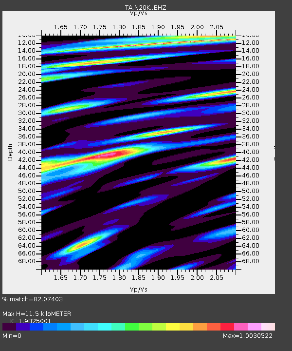
| Estimated Moho Depth: |
11.5 km |
| Estimated Crust Vp/Vs: |
1.98 |
| Assumed Crust Vp: |
6.566 km/s |
| Estimated Crust Vs: |
3.312 km/s |
| Estimated Crust Poisson's Ratio: |
0.33 |
|
| Radial Match: |
82.07403 % |
| Radial Bump: |
400 |
| Transverse Match: |
77.58002 % |
| Transverse Bump: |
400 |
| SOD ConfigId: |
13570011 |
| Insert Time: |
2019-05-01 17:29:39.888 +0000 |
| GWidth: |
2.5 |
| Max Bumps: |
400 |
| Tol: |
0.001 |
|

Signal To Noise
| Channel | StoN | STA | LTA |
| TA:N20K: :BHZ:20181102T11:07:11.899996Z | 19.001934 | 4.897191E-6 | 2.5772067E-7 |
| TA:N20K: :BHN:20181102T11:07:11.899996Z | 5.8914304 | 1.6293129E-6 | 2.7655642E-7 |
| TA:N20K: :BHE:20181102T11:07:11.899996Z | 15.976402 | 2.2782974E-6 | 1.4260391E-7 |
| Arrivals |
| Ps | 1.8 SECOND |
| PpPs | 4.9 SECOND |
| PsPs/PpSs | 6.7 SECOND |


