You are here: Home > Network List > TA - USArray Transportable Network (new EarthScope stations) Stations List
> Station 220A Playas Peak, Playas, NM, USA > Earthquake Result Viewer
220A Playas Peak, Playas, NM, USA - Earthquake Result Viewer
| Earthquake location: |
Loyalty Islands |
| Earthquake latitude/longitude: |
-20.9/168.8 |
| Earthquake time(UTC): |
2008/07/09 (191) 08:24:16 GMT |
| Earthquake Depth: |
39 km |
| Earthquake Magnitude: |
5.6 MB, 4.9 MS, 5.4 MW |
| Earthquake Catalog/Contributor: |
WHDF/NEIC |
|
| Network: |
TA USArray Transportable Network (new EarthScope stations) |
| Station: |
220A Playas Peak, Playas, NM, USA |
| Lat/Lon: |
31.90 N/108.53 W |
| Elevation: |
1395 m |
|
| Distance: |
94.9 deg |
| Az: |
57.86 deg |
| Baz: |
248.55 deg |
| Ray Param: |
0.040901463 |
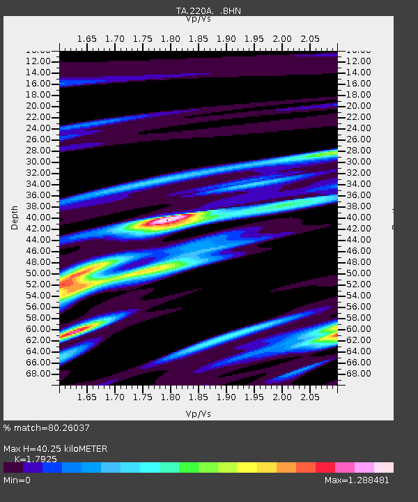
| Estimated Moho Depth: |
40.25 km |
| Estimated Crust Vp/Vs: |
1.79 |
| Assumed Crust Vp: |
6.182 km/s |
| Estimated Crust Vs: |
3.449 km/s |
| Estimated Crust Poisson's Ratio: |
0.27 |
|
| Radial Match: |
80.26037 % |
| Radial Bump: |
376 |
| Transverse Match: |
55.81241 % |
| Transverse Bump: |
400 |
| SOD ConfigId: |
2504 |
| Insert Time: |
2010-03-06 17:29:39.301 +0000 |
| GWidth: |
2.5 |
| Max Bumps: |
400 |
| Tol: |
0.001 |
|
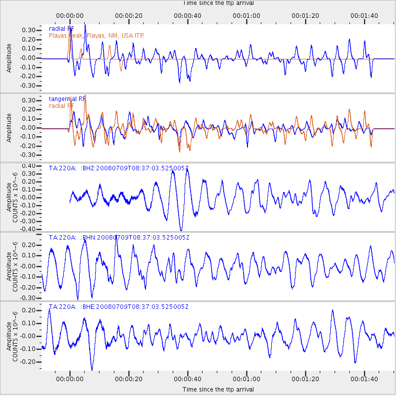
Signal To Noise
| Channel | StoN | STA | LTA |
| TA:220A: :BHN:20080709T08:37:03.525005Z | 1.7895948 | 1.6018356E-7 | 8.950828E-8 |
| TA:220A: :BHE:20080709T08:37:03.525005Z | 0.80525315 | 6.37782E-8 | 7.920267E-8 |
| TA:220A: :BHZ:20080709T08:37:03.525005Z | 3.2965682 | 1.8148648E-7 | 5.5053157E-8 |
| Arrivals |
| Ps | 5.3 SECOND |
| PpPs | 18 SECOND |
| PsPs/PpSs | 23 SECOND |


