You are here: Home > Network List > TA - USArray Transportable Network (new EarthScope stations) Stations List
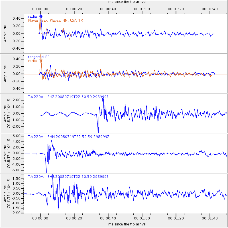
> Station 220A Playas Peak, Playas, NM, USA > Earthquake Result Viewer
220A Playas Peak, Playas, NM, USA - Earthquake Result Viewer
| Earthquake location: |
Fiji Islands Region |
| Earthquake latitude/longitude: |
-17.3/-177.3 |
| Earthquake time(UTC): |
2008/07/19 (201) 22:39:52 GMT |
| Earthquake Depth: |
391 km |
| Earthquake Magnitude: |
5.9 MB, 6.4 MW, 6.4 MW |
| Earthquake Catalog/Contributor: |
WHDF/NEIC |
|
| Network: |
TA USArray Transportable Network (new EarthScope stations) |
| Station: |
220A Playas Peak, Playas, NM, USA |
| Lat/Lon: |
31.90 N/108.53 W |
| Elevation: |
1395 m |
|
| Distance: |
82.1 deg |
| Az: |
53.184 deg |
| Baz: |
244.031 deg |
| Ray Param: |
0.046092667 |
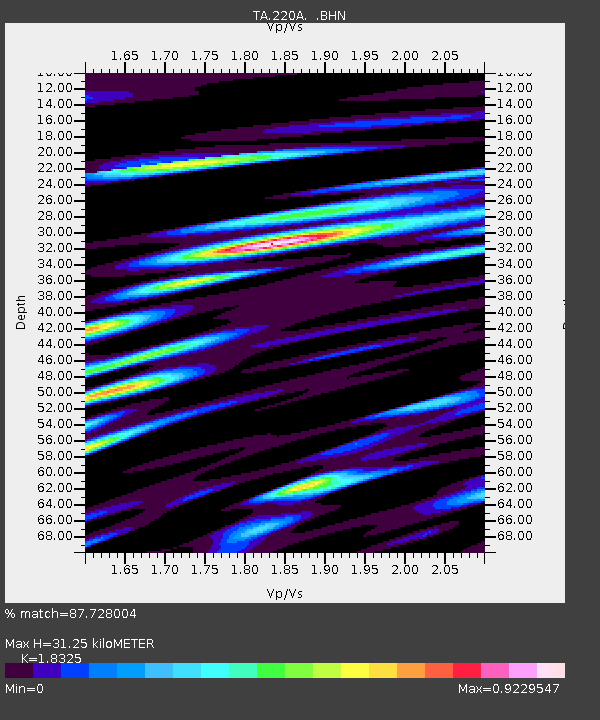
| Estimated Moho Depth: |
31.25 km |
| Estimated Crust Vp/Vs: |
1.83 |
| Assumed Crust Vp: |
6.182 km/s |
| Estimated Crust Vs: |
3.374 km/s |
| Estimated Crust Poisson's Ratio: |
0.29 |
|
| Radial Match: |
87.728004 % |
| Radial Bump: |
400 |
| Transverse Match: |
76.962425 % |
| Transverse Bump: |
400 |
| SOD ConfigId: |
2504 |
| Insert Time: |
2010-03-06 17:29:43.465 +0000 |
| GWidth: |
2.5 |
| Max Bumps: |
400 |
| Tol: |
0.001 |
|
Signal To Noise
| Channel | StoN | STA | LTA |
| TA:220A: :BHN:20080719T22:50:59.298999Z | 33.020542 | 2.3268688E-6 | 7.046731E-8 |
| TA:220A: :BHE:20080719T22:50:59.298999Z | 2.8396509 | 3.5579833E-7 | 1.252965E-7 |
| TA:220A: :BHZ:20080719T22:50:59.298999Z | 4.809513 | 8.7388133E-7 | 1.816985E-7 |
| Arrivals |
| Ps | 4.3 SECOND |
| PpPs | 14 SECOND |
| PsPs/PpSs | 18 SECOND |


