You are here: Home > Network List > TA - USArray Transportable Network (new EarthScope stations) Stations List
> Station 220A Playas Peak, Playas, NM, USA > Earthquake Result Viewer
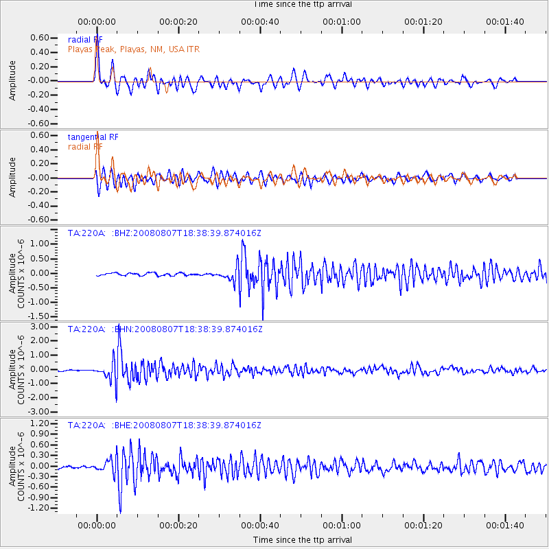
220A Playas Peak, Playas, NM, USA - Earthquake Result Viewer
| Earthquake location: |
Andreanof Islands, Aleutian Is. |
| Earthquake latitude/longitude: |
52.2/-175.7 |
| Earthquake time(UTC): |
2008/08/07 (220) 18:30:03 GMT |
| Earthquake Depth: |
12 km |
| Earthquake Magnitude: |
5.6 MB, 5.5 MS, 5.8 MW, 5.8 MW |
| Earthquake Catalog/Contributor: |
WHDF/NEIC |
|
| Network: |
TA USArray Transportable Network (new EarthScope stations) |
| Station: |
220A Playas Peak, Playas, NM, USA |
| Lat/Lon: |
31.90 N/108.53 W |
| Elevation: |
1395 m |
|
| Distance: |
51.8 deg |
| Az: |
85.387 deg |
| Baz: |
313.825 deg |
| Ray Param: |
0.06715123 |
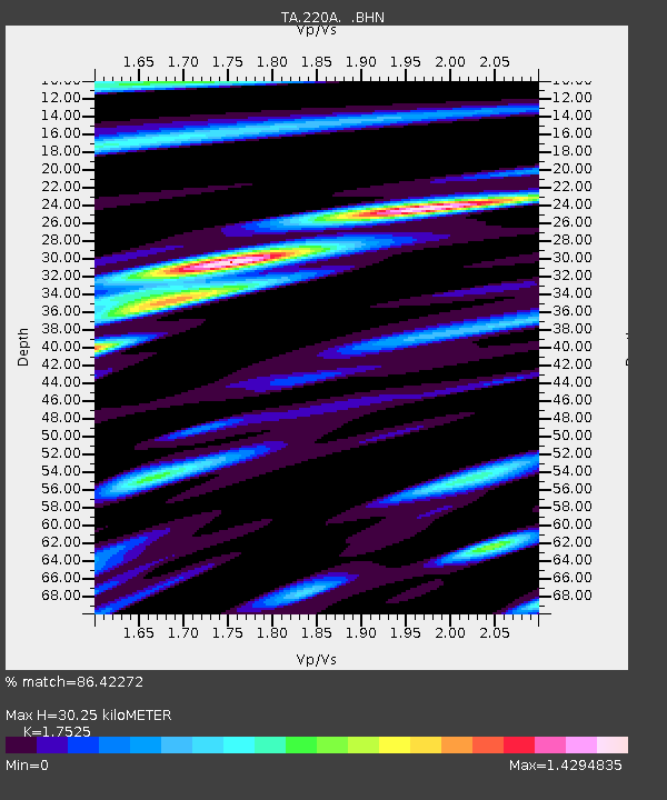
| Estimated Moho Depth: |
30.25 km |
| Estimated Crust Vp/Vs: |
1.75 |
| Assumed Crust Vp: |
6.182 km/s |
| Estimated Crust Vs: |
3.528 km/s |
| Estimated Crust Poisson's Ratio: |
0.26 |
|
| Radial Match: |
86.42272 % |
| Radial Bump: |
400 |
| Transverse Match: |
87.37198 % |
| Transverse Bump: |
400 |
| SOD ConfigId: |
2504 |
| Insert Time: |
2010-03-06 17:29:51.018 +0000 |
| GWidth: |
2.5 |
| Max Bumps: |
400 |
| Tol: |
0.001 |
|
Signal To Noise
| Channel | StoN | STA | LTA |
| TA:220A: :BHN:20080807T18:38:39.874016Z | 21.76077 | 6.693855E-7 | 3.076111E-8 |
| TA:220A: :BHE:20080807T18:38:39.874016Z | 4.447019 | 1.9218747E-7 | 4.3217145E-8 |
| TA:220A: :BHZ:20080807T18:38:39.874016Z | 5.296889 | 2.3016051E-7 | 4.345202E-8 |
| Arrivals |
| Ps | 3.9 SECOND |
| PpPs | 13 SECOND |
| PsPs/PpSs | 17 SECOND |


