You are here: Home > Network List > TA - USArray Transportable Network (new EarthScope stations) Stations List
> Station 220A Playas Peak, Playas, NM, USA > Earthquake Result Viewer
220A Playas Peak, Playas, NM, USA - Earthquake Result Viewer
| Earthquake location: |
Vanuatu Islands |
| Earthquake latitude/longitude: |
-13.5/167.0 |
| Earthquake time(UTC): |
2008/09/08 (252) 18:52:06 GMT |
| Earthquake Depth: |
110 km |
| Earthquake Magnitude: |
6.4 MB, 6.9 MW, 6.9 MW |
| Earthquake Catalog/Contributor: |
WHDF/NEIC |
|
| Network: |
TA USArray Transportable Network (new EarthScope stations) |
| Station: |
220A Playas Peak, Playas, NM, USA |
| Lat/Lon: |
31.90 N/108.53 W |
| Elevation: |
1395 m |
|
| Distance: |
92.5 deg |
| Az: |
57.929 deg |
| Baz: |
255.729 deg |
| Ray Param: |
0.04139522 |
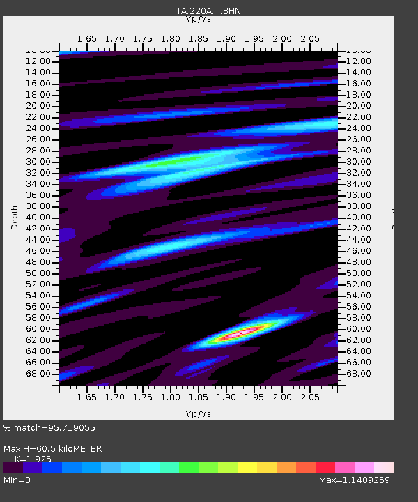
| Estimated Moho Depth: |
60.5 km |
| Estimated Crust Vp/Vs: |
1.92 |
| Assumed Crust Vp: |
6.182 km/s |
| Estimated Crust Vs: |
3.212 km/s |
| Estimated Crust Poisson's Ratio: |
0.32 |
|
| Radial Match: |
95.719055 % |
| Radial Bump: |
400 |
| Transverse Match: |
84.16307 % |
| Transverse Bump: |
400 |
| SOD ConfigId: |
2560 |
| Insert Time: |
2010-03-06 17:29:57.514 +0000 |
| GWidth: |
2.5 |
| Max Bumps: |
400 |
| Tol: |
0.001 |
|
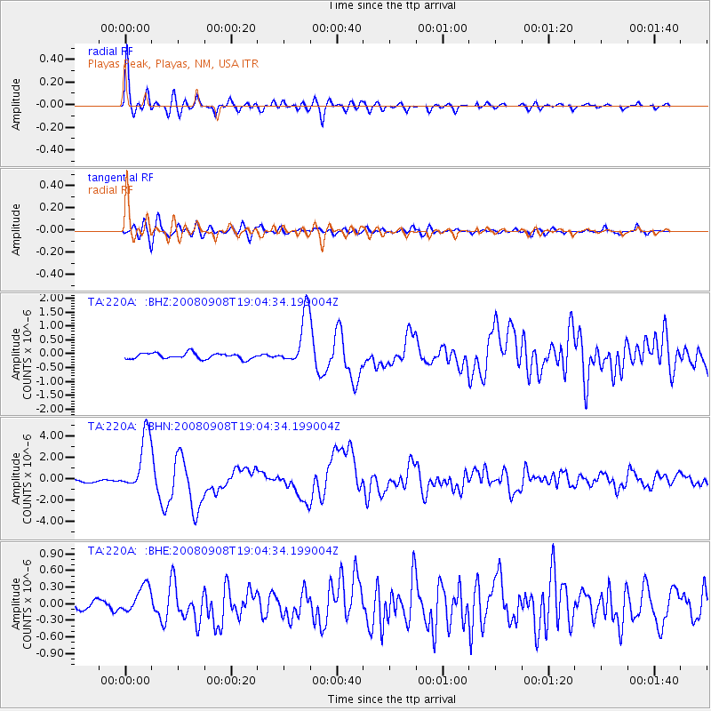
Signal To Noise
| Channel | StoN | STA | LTA |
| TA:220A: :BHN:20080908T19:04:34.199004Z | 17.770632 | 2.7248213E-6 | 1.5333283E-7 |
| TA:220A: :BHE:20080908T19:04:34.199004Z | 3.4052525 | 2.5536886E-7 | 7.4992634E-8 |
| TA:220A: :BHZ:20080908T19:04:34.199004Z | 9.209004 | 9.67612E-7 | 1.05072374E-7 |
| Arrivals |
| Ps | 9.2 SECOND |
| PpPs | 28 SECOND |
| PsPs/PpSs | 37 SECOND |


