You are here: Home > Network List > TA - USArray Transportable Network (new EarthScope stations) Stations List
> Station 220A Playas Peak, Playas, NM, USA > Earthquake Result Viewer
220A Playas Peak, Playas, NM, USA - Earthquake Result Viewer
| Earthquake location: |
Andreanof Islands, Aleutian Is. |
| Earthquake latitude/longitude: |
52.2/-178.7 |
| Earthquake time(UTC): |
2008/03/22 (082) 21:24:11 GMT |
| Earthquake Depth: |
132 km |
| Earthquake Magnitude: |
5.8 MB, 6.2 MW, 6.1 MW |
| Earthquake Catalog/Contributor: |
WHDF/NEIC |
|
| Network: |
TA USArray Transportable Network (new EarthScope stations) |
| Station: |
220A Playas Peak, Playas, NM, USA |
| Lat/Lon: |
31.90 N/108.53 W |
| Elevation: |
1395 m |
|
| Distance: |
53.7 deg |
| Az: |
83.105 deg |
| Baz: |
314.045 deg |
| Ray Param: |
0.06549167 |
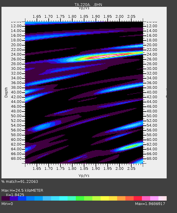
| Estimated Moho Depth: |
24.5 km |
| Estimated Crust Vp/Vs: |
1.94 |
| Assumed Crust Vp: |
6.182 km/s |
| Estimated Crust Vs: |
3.183 km/s |
| Estimated Crust Poisson's Ratio: |
0.32 |
|
| Radial Match: |
91.22063 % |
| Radial Bump: |
380 |
| Transverse Match: |
86.26763 % |
| Transverse Bump: |
400 |
| SOD ConfigId: |
2564 |
| Insert Time: |
2010-03-06 17:30:10.576 +0000 |
| GWidth: |
2.5 |
| Max Bumps: |
400 |
| Tol: |
0.001 |
|
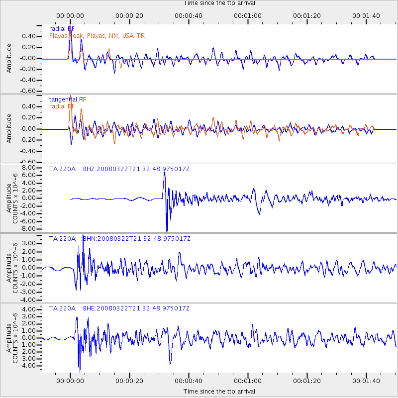
Signal To Noise
| Channel | StoN | STA | LTA |
| TA:220A: :BHN:20080322T21:32:48.975017Z | 7.3966775 | 1.2770092E-6 | 1.7264634E-7 |
| TA:220A: :BHE:20080322T21:32:48.975017Z | 16.330547 | 1.5209527E-6 | 9.313544E-8 |
| TA:220A: :BHZ:20080322T21:32:48.975017Z | 19.104399 | 3.211154E-6 | 1.6808454E-7 |
| Arrivals |
| Ps | 3.9 SECOND |
| PpPs | 11 SECOND |
| PsPs/PpSs | 15 SECOND |


