You are here: Home > Network List > TA - USArray Transportable Network (new EarthScope stations) Stations List
> Station 220A Playas Peak, Playas, NM, USA > Earthquake Result Viewer
220A Playas Peak, Playas, NM, USA - Earthquake Result Viewer
| Earthquake location: |
Santa Cruz Islands Region |
| Earthquake latitude/longitude: |
-11.0/164.5 |
| Earthquake time(UTC): |
2008/07/19 (201) 09:27:01 GMT |
| Earthquake Depth: |
11 km |
| Earthquake Magnitude: |
6.1 MB, 6.4 MS, 6.6 MW, 6.6 MW |
| Earthquake Catalog/Contributor: |
WHDF/NEIC |
|
| Network: |
TA USArray Transportable Network (new EarthScope stations) |
| Station: |
220A Playas Peak, Playas, NM, USA |
| Lat/Lon: |
31.90 N/108.53 W |
| Elevation: |
1395 m |
|
| Distance: |
93.2 deg |
| Az: |
58.286 deg |
| Baz: |
259.086 deg |
| Ray Param: |
0.04130431 |
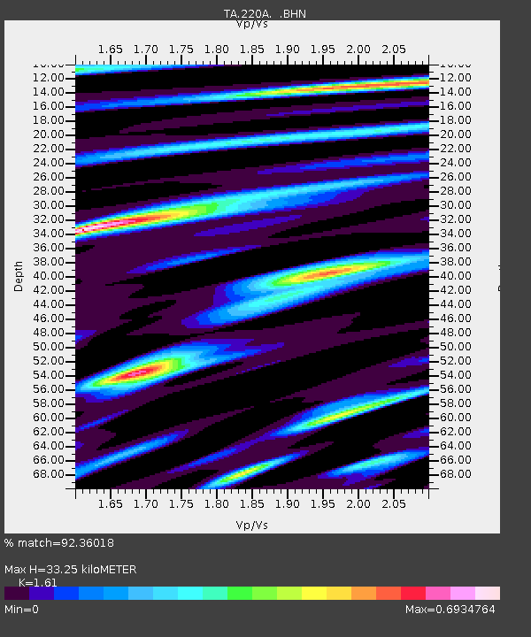
| Estimated Moho Depth: |
33.25 km |
| Estimated Crust Vp/Vs: |
1.61 |
| Assumed Crust Vp: |
6.182 km/s |
| Estimated Crust Vs: |
3.84 km/s |
| Estimated Crust Poisson's Ratio: |
0.19 |
|
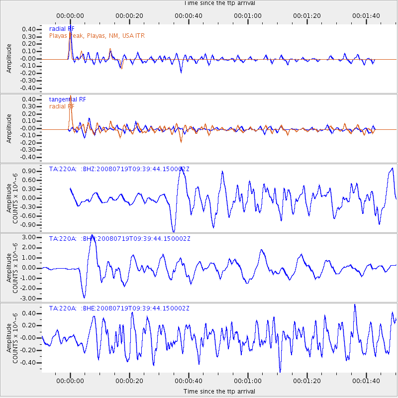
| Radial Match: |
92.36018 % |
| Radial Bump: |
400 |
| Transverse Match: |
74.17937 % |
| Transverse Bump: |
400 |
| SOD ConfigId: |
2658 |
| Insert Time: |
2010-03-06 17:30:13.154 +0000 |
| GWidth: |
2.5 |
| Max Bumps: |
400 |
| Tol: |
0.001 |
|
Signal To Noise
| Channel | StoN | STA | LTA |
| TA:220A: :BHN:20080719T09:39:44.150002Z | 10.227192 | 1.083651E-6 | 1.0595782E-7 |
| TA:220A: :BHE:20080719T09:39:44.150002Z | 0.7862595 | 8.309735E-8 | 1.0568693E-7 |
| TA:220A: :BHZ:20080719T09:39:44.150002Z | 3.1288733 | 3.875643E-7 | 1.2386705E-7 |
| Arrivals |
| Ps | 3.3 SECOND |
| PpPs | 14 SECOND |
| PsPs/PpSs | 17 SECOND |


