You are here: Home > Network List > TA - USArray Transportable Network (new EarthScope stations) Stations List
> Station 220A Playas Peak, Playas, NM, USA > Earthquake Result Viewer
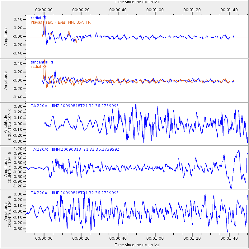
220A Playas Peak, Playas, NM, USA - Earthquake Result Viewer

| Earthquake location: |
South Of Fiji Islands |
| Earthquake latitude/longitude: |
-26.1/-178.4 |
| Earthquake time(UTC): |
2009/08/18 (230) 21:20:47 GMT |
| Earthquake Depth: |
270 km |
| Earthquake Magnitude: |
5.5 MB, 6.3 MW, 6.3 MW |
| Earthquake Catalog/Contributor: |
WHDF/NEIC |
|
| Network: |
TA USArray Transportable Network (new EarthScope stations) |
| Station: |
220A Playas Peak, Playas, NM, USA |
| Lat/Lon: |
31.90 N/108.53 W |
| Elevation: |
1395 m |
|
| Distance: |
88.1 deg |
| Az: |
53.033 deg |
| Baz: |
237.668 deg |
| Ray Param: |
0.042198107 |
| Estimated Moho Depth: |
30.0 km |
| Estimated Crust Vp/Vs: |
1.96 |
| Assumed Crust Vp: |
6.182 km/s |
| Estimated Crust Vs: |
3.158 km/s |
| Estimated Crust Poisson's Ratio: |
0.32 |
|
| Radial Match: |
82.62228 % |
| Radial Bump: |
400 |
| Transverse Match: |
61.038654 % |
| Transverse Bump: |
400 |
| SOD ConfigId: |
2622 |
| Insert Time: |
2010-03-06 17:30:29.164 +0000 |
| GWidth: |
2.5 |
| Max Bumps: |
400 |
| Tol: |
0.001 |
|
Signal To Noise
| Channel | StoN | STA | LTA |
| TA:220A: :BHN:20090818T21:32:36.273999Z | 7.5789013 | 2.862778E-7 | 3.7772995E-8 |
| TA:220A: :BHE:20090818T21:32:36.273999Z | 1.2990589 | 6.744184E-8 | 5.1915922E-8 |
| TA:220A: :BHZ:20090818T21:32:36.273999Z | 1.6264029 | 1.0556653E-7 | 6.490799E-8 |
| Arrivals |
| Ps | 4.7 SECOND |
| PpPs | 14 SECOND |
| PsPs/PpSs | 19 SECOND |


