You are here: Home > Network List > WY - Yellowstone Wyoming Seismic Network Stations List
> Station YUF Upper Falls, WY, USA > Earthquake Result Viewer
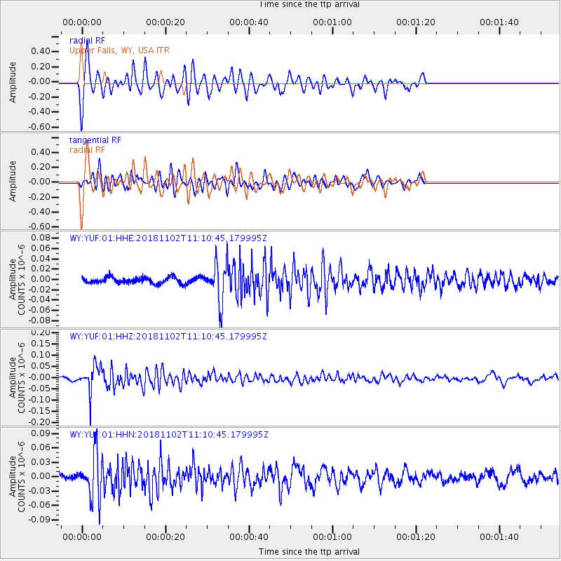
YUF Upper Falls, WY, USA - Earthquake Result Viewer
*The percent match for this event was below the threshold and hence no stack was calculated.
| Earthquake location: |
Northwest Of Kuril Islands |
| Earthquake latitude/longitude: |
47.8/146.7 |
| Earthquake time(UTC): |
2018/11/02 (306) 11:01:15 GMT |
| Earthquake Depth: |
432 km |
| Earthquake Magnitude: |
5.9 Mww |
| Earthquake Catalog/Contributor: |
NEIC PDE/us |
|
| Network: |
WY Yellowstone Wyoming Seismic Network |
| Station: |
YUF Upper Falls, WY, USA |
| Lat/Lon: |
44.71 N/110.51 W |
| Elevation: |
2394 m |
|
| Distance: |
65.7 deg |
| Az: |
49.734 deg |
| Baz: |
313.839 deg |
| Ray Param: |
$rayparam |
*The percent match for this event was below the threshold and hence was not used in the summary stack. |
|
| Radial Match: |
68.268265 % |
| Radial Bump: |
400 |
| Transverse Match: |
61.127266 % |
| Transverse Bump: |
400 |
| SOD ConfigId: |
13570011 |
| Insert Time: |
2019-05-01 17:32:19.870 +0000 |
| GWidth: |
2.5 |
| Max Bumps: |
400 |
| Tol: |
0.001 |
|
Signal To Noise
| Channel | StoN | STA | LTA |
| WY:YUF:01:HHZ:20181102T11:10:45.179995Z | 10.372486 | 5.8561227E-8 | 5.645824E-9 |
| WY:YUF:01:HHN:20181102T11:10:45.179995Z | 5.386135 | 4.721372E-8 | 8.765789E-9 |
| WY:YUF:01:HHE:20181102T11:10:45.179995Z | 6.234358 | 3.7738E-8 | 6.05323E-9 |
| Arrivals |
| Ps | |
| PpPs | |
| PsPs/PpSs | |


