You are here: Home > Network List > TS - TERRAscope (Southern California Seismic Network) Stations List
> Station BAR Barrett Dam, California, USA > Earthquake Result Viewer
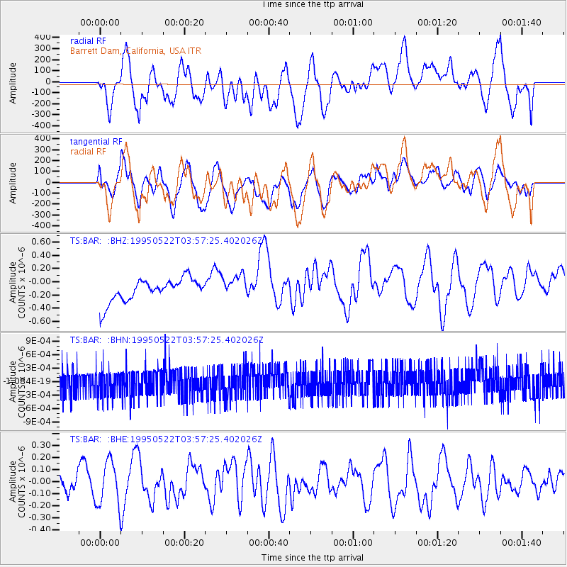
BAR Barrett Dam, California, USA - Earthquake Result Viewer
*The percent match for this event was below the threshold and hence no stack was calculated.
| Earthquake location: |
Southeast Of Loyalty Islands |
| Earthquake latitude/longitude: |
-22.8/169.9 |
| Earthquake time(UTC): |
1995/05/22 (142) 03:45:04 GMT |
| Earthquake Depth: |
33 km |
| Earthquake Magnitude: |
5.8 MB, 6.1 MS, 6.4 UNKNOWN, 6.1 MW |
| Earthquake Catalog/Contributor: |
WHDF/NEIC |
|
| Network: |
TS TERRAscope (Southern California Seismic Network) |
| Station: |
BAR Barrett Dam, California, USA |
| Lat/Lon: |
32.68 N/116.67 W |
| Elevation: |
548 m |
|
| Distance: |
89.1 deg |
| Az: |
53.928 deg |
| Baz: |
242.203 deg |
| Ray Param: |
$rayparam |
*The percent match for this event was below the threshold and hence was not used in the summary stack. |
|
| Radial Match: |
42.64898 % |
| Radial Bump: |
400 |
| Transverse Match: |
49.564056 % |
| Transverse Bump: |
400 |
| SOD ConfigId: |
4480 |
| Insert Time: |
2010-02-26 13:59:57.130 +0000 |
| GWidth: |
2.5 |
| Max Bumps: |
400 |
| Tol: |
0.001 |
|
Signal To Noise
| Channel | StoN | STA | LTA |
| TS:BAR: :BHN:19950522T03:57:25.402026Z | 1.1376903 | 3.0355135E-10 | 2.6681368E-10 |
| TS:BAR: :BHE:19950522T03:57:25.402026Z | 3.1097963 | 1.8535394E-7 | 5.960324E-8 |
| TS:BAR: :BHZ:19950522T03:57:25.402026Z | 1.005072 | 1.7371504E-7 | 1.728384E-7 |
| Arrivals |
| Ps | |
| PpPs | |
| PsPs/PpSs | |


