You are here: Home > Network List > TA - USArray Transportable Network (new EarthScope stations) Stations List
> Station 220A Playas Peak, Playas, NM, USA > Earthquake Result Viewer
220A Playas Peak, Playas, NM, USA - Earthquake Result Viewer
| Earthquake location: |
South Of Panama |
| Earthquake latitude/longitude: |
5.0/-82.7 |
| Earthquake time(UTC): |
2008/06/17 (169) 17:42:09 GMT |
| Earthquake Depth: |
10 km |
| Earthquake Magnitude: |
5.6 MB, 5.3 MS, 5.9 MW, 5.9 MW |
| Earthquake Catalog/Contributor: |
WHDF/NEIC |
|
| Network: |
TA USArray Transportable Network (new EarthScope stations) |
| Station: |
220A Playas Peak, Playas, NM, USA |
| Lat/Lon: |
31.90 N/108.53 W |
| Elevation: |
1395 m |
|
| Distance: |
36.1 deg |
| Az: |
320.954 deg |
| Baz: |
132.45 deg |
| Ray Param: |
0.076864295 |
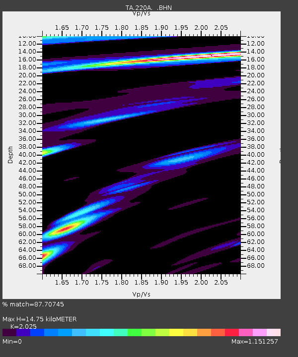
| Estimated Moho Depth: |
14.75 km |
| Estimated Crust Vp/Vs: |
2.03 |
| Assumed Crust Vp: |
6.182 km/s |
| Estimated Crust Vs: |
3.053 km/s |
| Estimated Crust Poisson's Ratio: |
0.34 |
|
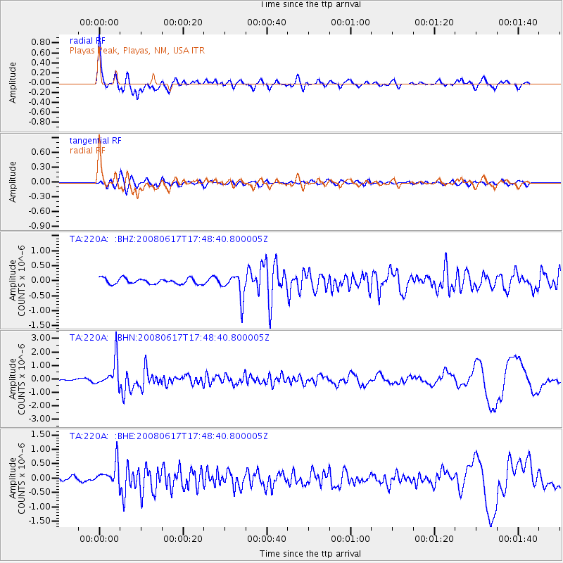
| Radial Match: |
87.70745 % |
| Radial Bump: |
400 |
| Transverse Match: |
72.39397 % |
| Transverse Bump: |
400 |
| SOD ConfigId: |
2504 |
| Insert Time: |
2010-03-06 17:31:34.362 +0000 |
| GWidth: |
2.5 |
| Max Bumps: |
400 |
| Tol: |
0.001 |
|
Signal To Noise
| Channel | StoN | STA | LTA |
| TA:220A: :BHN:20080617T17:48:40.800005Z | 11.921884 | 1.0400637E-6 | 8.723988E-8 |
| TA:220A: :BHE:20080617T17:48:40.800005Z | 3.9104433 | 4.073223E-7 | 1.04162694E-7 |
| TA:220A: :BHZ:20080617T17:48:40.800005Z | 4.587164 | 4.2278697E-7 | 9.2167404E-8 |
| Arrivals |
| Ps | 2.6 SECOND |
| PpPs | 6.8 SECOND |
| PsPs/PpSs | 9.4 SECOND |


