You are here: Home > Network List > TA - USArray Transportable Network (new EarthScope stations) Stations List
> Station O17K Koliganek, Bristol Bay, AK, USA > Earthquake Result Viewer
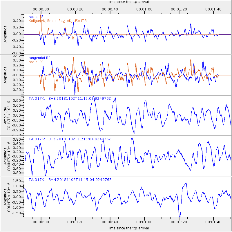
O17K Koliganek, Bristol Bay, AK, USA - Earthquake Result Viewer
*The percent match for this event was below the threshold and hence no stack was calculated.
| Earthquake location: |
Reykjanes Ridge |
| Earthquake latitude/longitude: |
57.3/-33.0 |
| Earthquake time(UTC): |
2018/11/02 (306) 11:06:02 GMT |
| Earthquake Depth: |
10 km |
| Earthquake Magnitude: |
5.3 Mww |
| Earthquake Catalog/Contributor: |
NEIC PDE/us |
|
| Network: |
TA USArray Transportable Network (new EarthScope stations) |
| Station: |
O17K Koliganek, Bristol Bay, AK, USA |
| Lat/Lon: |
59.77 N/157.09 W |
| Elevation: |
156 m |
|
| Distance: |
55.2 deg |
| Az: |
329.312 deg |
| Baz: |
33.216 deg |
| Ray Param: |
$rayparam |
*The percent match for this event was below the threshold and hence was not used in the summary stack. |
|
| Radial Match: |
43.35283 % |
| Radial Bump: |
324 |
| Transverse Match: |
59.758385 % |
| Transverse Bump: |
349 |
| SOD ConfigId: |
13570011 |
| Insert Time: |
2019-05-01 17:40:39.229 +0000 |
| GWidth: |
2.5 |
| Max Bumps: |
400 |
| Tol: |
0.001 |
|
Signal To Noise
| Channel | StoN | STA | LTA |
| TA:O17K: :BHZ:20181102T11:15:04.924976Z | 1.1108769 | 4.8666493E-7 | 4.3809078E-7 |
| TA:O17K: :BHN:20181102T11:15:04.924976Z | 0.9976202 | 4.763389E-7 | 4.7747517E-7 |
| TA:O17K: :BHE:20181102T11:15:04.924976Z | 2.3654118 | 7.953076E-7 | 3.3622374E-7 |
| Arrivals |
| Ps | |
| PpPs | |
| PsPs/PpSs | |


