You are here: Home > Network List > TA - USArray Transportable Network (new EarthScope stations) Stations List
> Station K15K Wolf Creek Mountain, AK, USA > Earthquake Result Viewer
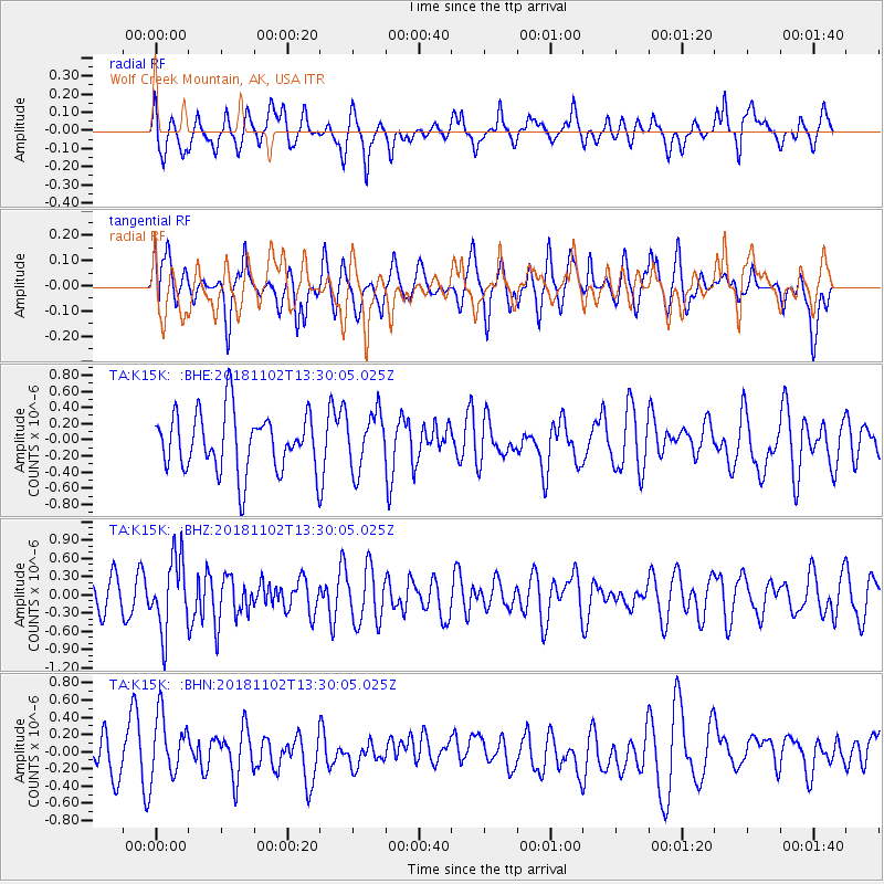
K15K Wolf Creek Mountain, AK, USA - Earthquake Result Viewer
*The percent match for this event was below the threshold and hence no stack was calculated.
| Earthquake location: |
New Britain Region, P.N.G. |
| Earthquake latitude/longitude: |
-6.4/153.4 |
| Earthquake time(UTC): |
2018/11/02 (306) 13:18:45 GMT |
| Earthquake Depth: |
10 km |
| Earthquake Magnitude: |
5.4 Mww |
| Earthquake Catalog/Contributor: |
NEIC PDE/us |
|
| Network: |
TA USArray Transportable Network (new EarthScope stations) |
| Station: |
K15K Wolf Creek Mountain, AK, USA |
| Lat/Lon: |
62.29 N/161.53 W |
| Elevation: |
346 m |
|
| Distance: |
76.7 deg |
| Az: |
19.868 deg |
| Baz: |
226.277 deg |
| Ray Param: |
$rayparam |
*The percent match for this event was below the threshold and hence was not used in the summary stack. |
|
| Radial Match: |
59.75433 % |
| Radial Bump: |
400 |
| Transverse Match: |
39.828228 % |
| Transverse Bump: |
400 |
| SOD ConfigId: |
13570011 |
| Insert Time: |
2019-05-01 17:48:07.553 +0000 |
| GWidth: |
2.5 |
| Max Bumps: |
400 |
| Tol: |
0.001 |
|
Signal To Noise
| Channel | StoN | STA | LTA |
| TA:K15K: :BHZ:20181102T13:30:05.025Z | 2.1968472 | 5.933699E-7 | 2.7010066E-7 |
| TA:K15K: :BHN:20181102T13:30:05.025Z | 1.8429854 | 3.5537434E-7 | 1.9282537E-7 |
| TA:K15K: :BHE:20181102T13:30:05.025Z | 0.9738548 | 3.520699E-7 | 3.6152196E-7 |
| Arrivals |
| Ps | |
| PpPs | |
| PsPs/PpSs | |


