You are here: Home > Network List > TA - USArray Transportable Network (new EarthScope stations) Stations List
> Station 220A Playas Peak, Playas, NM, USA > Earthquake Result Viewer
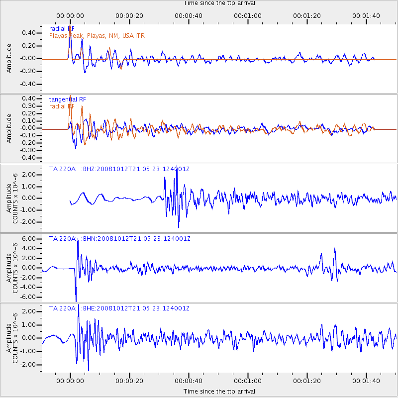
220A Playas Peak, Playas, NM, USA - Earthquake Result Viewer
*The percent match for this event was below the threshold and hence no stack was calculated.
| Earthquake location: |
Southern Bolivia |
| Earthquake latitude/longitude: |
-20.1/-65.0 |
| Earthquake time(UTC): |
2008/10/12 (286) 20:55:41 GMT |
| Earthquake Depth: |
353 km |
| Earthquake Magnitude: |
6.0 MB, 6.2 MW, 6.2 MW |
| Earthquake Catalog/Contributor: |
WHDF/NEIC |
|
| Network: |
TA USArray Transportable Network (new EarthScope stations) |
| Station: |
220A Playas Peak, Playas, NM, USA |
| Lat/Lon: |
31.90 N/108.53 W |
| Elevation: |
1395 m |
|
| Distance: |
66.5 deg |
| Az: |
320.265 deg |
| Baz: |
135.068 deg |
| Ray Param: |
$rayparam |
*The percent match for this event was below the threshold and hence was not used in the summary stack. |
|
| Radial Match: |
78.39365 % |
| Radial Bump: |
388 |
| Transverse Match: |
71.77584 % |
| Transverse Bump: |
400 |
| SOD ConfigId: |
2556 |
| Insert Time: |
2010-03-06 17:32:16.097 +0000 |
| GWidth: |
2.5 |
| Max Bumps: |
400 |
| Tol: |
0.001 |
|
Signal To Noise
| Channel | StoN | STA | LTA |
| TA:220A: :BHN:20081012T21:05:23.124001Z | 6.539135 | 2.3008101E-6 | 3.5185235E-7 |
| TA:220A: :BHE:20081012T21:05:23.124001Z | 3.595844 | 9.0605056E-7 | 2.5197158E-7 |
| TA:220A: :BHZ:20081012T21:05:23.124001Z | 2.8929567 | 6.7271696E-7 | 2.3253614E-7 |
| Arrivals |
| Ps | |
| PpPs | |
| PsPs/PpSs | |


