You are here: Home > Network List > TA - USArray Transportable Network (new EarthScope stations) Stations List
> Station 220A Playas Peak, Playas, NM, USA > Earthquake Result Viewer
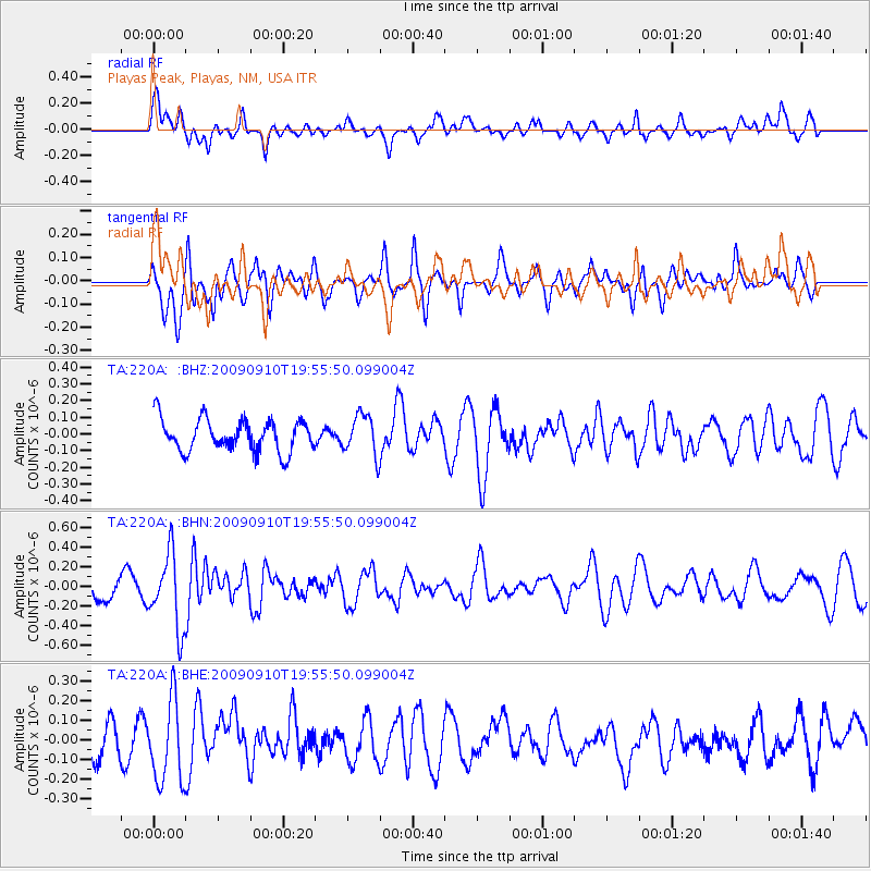
220A Playas Peak, Playas, NM, USA - Earthquake Result Viewer
*The percent match for this event was below the threshold and hence no stack was calculated.
| Earthquake location: |
Easter Island Region |
| Earthquake latitude/longitude: |
-29.9/-111.8 |
| Earthquake time(UTC): |
2009/09/10 (253) 19:46:03 GMT |
| Earthquake Depth: |
10 km |
| Earthquake Magnitude: |
5.5 MW, 5.4 MB |
| Earthquake Catalog/Contributor: |
WHDF/NEIC |
|
| Network: |
TA USArray Transportable Network (new EarthScope stations) |
| Station: |
220A Playas Peak, Playas, NM, USA |
| Lat/Lon: |
31.90 N/108.53 W |
| Elevation: |
1395 m |
|
| Distance: |
61.6 deg |
| Az: |
3.189 deg |
| Baz: |
183.255 deg |
| Ray Param: |
$rayparam |
*The percent match for this event was below the threshold and hence was not used in the summary stack. |
|
| Radial Match: |
54.081745 % |
| Radial Bump: |
400 |
| Transverse Match: |
58.18759 % |
| Transverse Bump: |
400 |
| SOD ConfigId: |
2622 |
| Insert Time: |
2010-03-06 17:32:35.319 +0000 |
| GWidth: |
2.5 |
| Max Bumps: |
400 |
| Tol: |
0.001 |
|
Signal To Noise
| Channel | StoN | STA | LTA |
| TA:220A: :BHN:20090910T19:55:50.099004Z | 4.0775394 | 3.7640442E-7 | 9.231165E-8 |
| TA:220A: :BHE:20090910T19:55:50.099004Z | 2.2427866 | 2.0848961E-7 | 9.2960065E-8 |
| TA:220A: :BHZ:20090910T19:55:50.099004Z | 1.2712921 | 1.2133523E-7 | 9.544246E-8 |
| Arrivals |
| Ps | |
| PpPs | |
| PsPs/PpSs | |


